Filter results
You can narrow down the results using the filters
Audience
Topics
Our work
Diseases
11744 results
-
Budget 2019–20: More Choices for a Longer Life – strengthened regulation through risk based targeting and information sharing
This Budget fact sheet outlines how the Government will introduce a new way to target and respond to poorly performing aged care providers. -
Budget 2019–20: More Choices for a Longer Life – home care compliance – risk based monitoring and assessment
This Budget fact sheet outlines how the Government will strengthen protections to make sure aged care services are being delivered safely to senior Australians in their homes. -
Budget 2019–20: More Choices for a Longer Life – enhanced home care dementia cognition and support
This Budget fact sheet outlines how the Government will increase the supplement paid to people receiving home care who are living with moderate to severe dementia. -
Budget 2019–20: More Choices for a Longer Life – further enhancing safety in aged care
This Budget fact sheet outlines how the Government will improve compliance in aged care by further enhancing the quality, safety and integrity of home care packages – including audits and reviews of quality and safety with providers. -
Budget 2019–20: More Choices for a Longer Life – supporting implementation of the Aged Care Workforce Strategy
This Budget fact sheet outlines how the Government is continuing its commitment to improving the quality of aged care services by working with the industry to build an aged care workforce that will meet Australia’s future needs. -
Budget 2019–20: More Choices for a Longer Life – trial of alternative residential aged care funding tool
This Budget fact sheet outlines how the Government will trial a new residential aged care funding tool to replace the longstanding Aged Care Funding Instrument (ACFI). -
Budget 2019–20: More Choices for a Longer Life – support providers through business advisory services
This Budget fact sheet outlines how the Government will provide accounting and business advisory help to aged care providers at risk of, or under, financial stress – often smaller providers servicing rural and remote areas. -
Budget 2019–20: Preventive Health – establishment of a centralised Donor Human Milk Service
This Budget fact sheet outlines how the Government will provide a one-off grant to the Australian Red Cross Blood Service to ensure that all premature babies born in Australia can access human milk. -
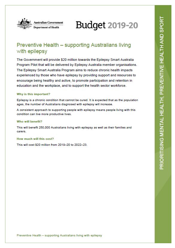
Budget 2019–20: Preventive Health – supporting Australians living with epilepsy
This Budget fact sheet outlines how the Government will provide $20 million towards the Epilepsy Smart Australia Program Pilot that will be delivered by Epilepsy Australia member organisations. -
Health Portfolio Budget Statements 2019–20
The Health Portfolio Budget Statements for the 2019 to 2020 financial year outline how the Government has allocated resources to outcomes for all entities within our portfolio. -

Protect your baby from whooping cough. Vaccinate for free when pregnant – poster
This poster aims to prompt pregnant women to think about getting the free whooping cough vaccine when pregnant. -
Exploratory Research on School Based Immunisation – Qualitative Research Report
This research was conducted to further understand the knowledge base for adolescents and their parents around school-based vaccinations. -
National Men's Health Strategy 2020–2030
This strategy outlines Australia’s national approach to improving the health of men and boys – particularly those at greatest risk of poor health – and to reducing inequities between different groups. -
Australian Government response to the Joint Standing Committee on the NDIS report – NDIS ICT Systems
The Australian Government welcomes the report of the Joint Standing Committee on the National Disability Insurance Scheme (the Committee) Inquiry into NDIS ICT Systems (the Report). -

Home Care Packages Program Data Reports
These quarterly reports provide an update on the operation of the Home Care Packages Program. They include statistics on assessment, approvals, services, people waiting for services, wait times and maximum exit amounts. -
Life Saving Drugs Program – Fabry disease – Medicines review protocol
This final protocol describes the methodology reviewers will follow to assess use of Life Saving Drugs Program medicines for Fabry disease. -
Life Saving Drugs Program – Gaucher disease (type 1) – Medicines review protocol
This final protocol describes the methodology reviewers will follow to assess use of enzyme replacement medicines under the Life Saving Drugs Program medicines for Gaucher disease (type 1). -
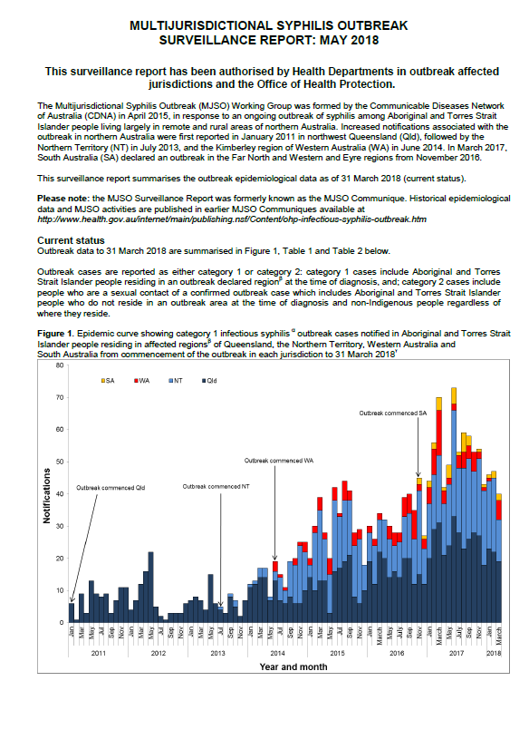
Multijurisdictional Syphilis Outbreak (MJSO) Surveillance Report – consolidated reports May 2018 to January 2019
The surveillance reports summarise the status of an ongoing outbreak of infectious syphilis among Aboriginal and Torres Strait Islander people in remote and rural areas of northern Australia. This report consolidates the monthly surveillance reports from May 2018 to January 2019. -
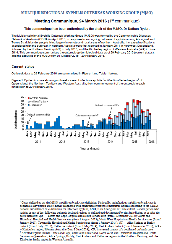
Multijurisdictional Syphilis Outbreak (MJSO) Surveillance Report – consolidated reports March 2016 to February 2018
The surveillance reports summarise the status of an ongoing outbreak of infectious syphilis among Aboriginal and Torres Strait Islander people in remote and rural areas of northern Australia. This report consolidates the monthly surveillance reports from March 2016 to February 2018. -
Review of the Transition Care Programme – Final Report
This review showed that the program plays an effective and important role where Australia’s health and aged care systems meet. It has supported the early discharge of older people from hospital and can help delay their entry into residential care. -
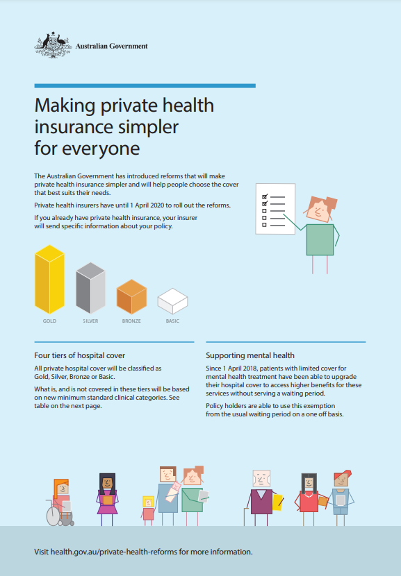
Making private health insurance simpler for everyone – fact sheet
This fact sheet describes the Government’s reforms to private health insurance. -
Australian Government Response to the Joint Standing Committee – Provision of Assistive Technology under the NDIS
The Joint Standing Committee on the National Disability Insurance Scheme (the Committee) released a report into the provision of Assistive Technology (AT) under the National Disability Insurance Scheme (NDIS) in December 2018. -
National Strategic Action Plan for Inflammatory Bowel Disease
The National Strategic Action Plan for Inflammatory Bowel Disease (IBD) provides a path to better care, better quality of life and reduced burden of IBD for the Australian community. -
National Strategic Action Plan for Arthritis
The National Strategic Action Plan for Arthritis aims to guide national efforts to address the burden of arthritis. -
Review of implementation of the National Disability Strategy 2010–2020
As part of the development of Australia’s Disability Strategy 2021–2031, the Department of Social Services engaged the Social Policy Research Centre of the University of New South Wales to undertake an independent, targeted review of implementation of the National Disability Strategy 2010–2020.