Coordinated primary health care near you
There are 31 PHNs across Australia, each responsible for its own region.
You can find your local PHN via your state or territory page for:
- Australian Capital Territory
- New South Wales
- Northern Territory
- Queensland
- South Australia
- Tasmania
- Victoria
- Western Australia.
You can see all 31 PHNs on our national map of boundaries or printable wall map.
Find your local PHN
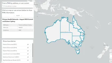
Primary Health Network (PHN) locator
Use our locator map to find the location, boundaries and contact details of Primary Health Networks (PHNs). You can overlap this with other area boundaries, such as local government areas.
Primary Health Network profiles and resources
For each PHN, you can access:
- a demographics fact sheet
- a topographic map
- remoteness area maps
- a socioeconomic disadvantage map.
We have listed these in state and territory resource collections, which you can access from:
Date last updated: