Filter results
You can narrow down the results using the filters
Audience
Topics
Our work
Diseases
405 results
-
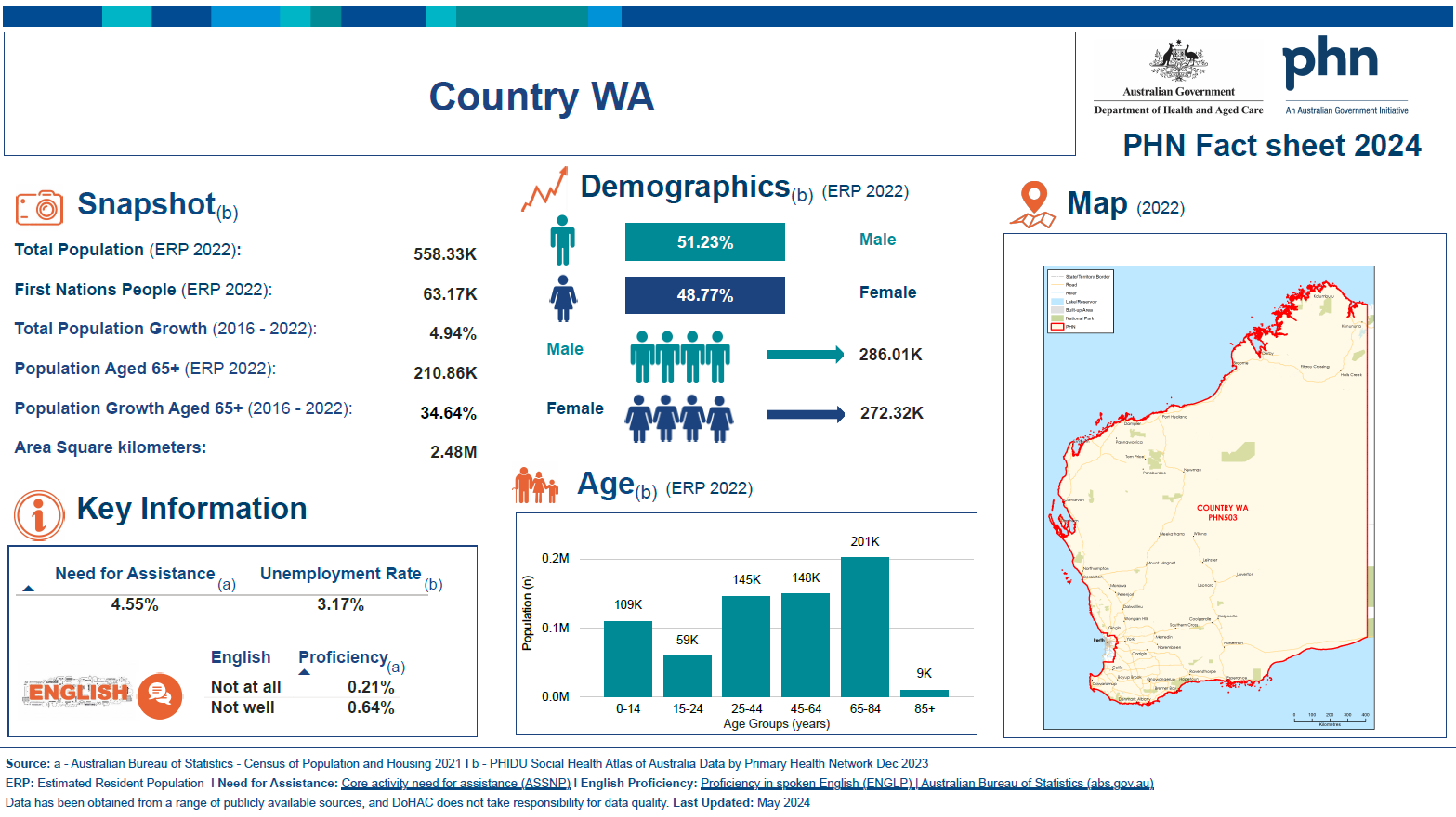
Country Western Australia Primary Health Network (PHN) fact sheet
This fact sheet contains demographic information for the Country Western Australia Primary Health Network (PHN). -
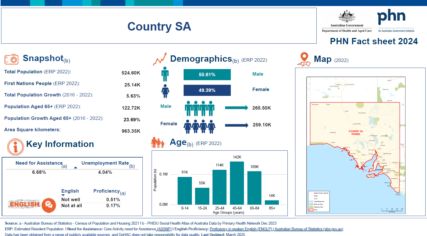
Country South Australia Primary Health Network (PHN) fact sheet
This fact sheet contains demographic information for the Country South Australia Primary Health Network (PHN). -
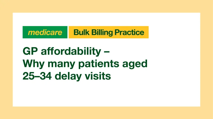 02:55
02:55GP affordability – Why many patients aged 25–34 delay visits
Find out how rising patient out-of-pocket costs are causing young people to delay visiting their GP. -
Clinical Trials in Australian Public Health Institutions 2018-19 (NAS 4 report)
This report is the Framework for National Aggregate Statistics (NAS) and annual collection of data by all jurisdictions through the Clinical Trials Project Reference Group (CTPRG). -
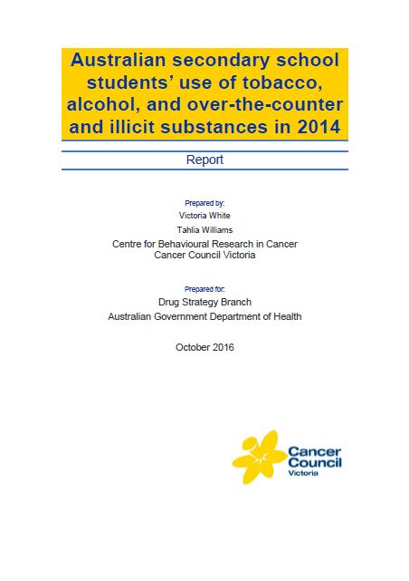
Secondary school students’ use of tobacco, alcohol and other drugs in 2014
This report presents the results of the Australian Secondary Students’ Alcohol and Drug (ASSAD) survey. It includes statistics on the use of tobacco, alcohol, electronic cigarettes, over-the-counter drugs, illicit drugs and health services. -

Coronavirus (COVID-19) at a glance – 19 October 2021
This infographic provides a quick view of the coronavirus (COVID-19) situation in Australia on 19 October 2021. -
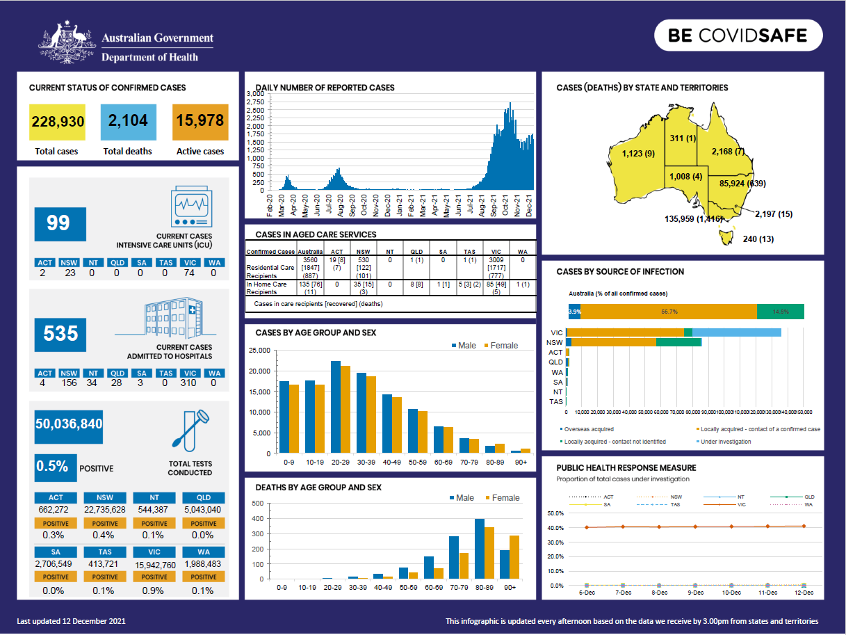
Coronavirus (COVID-19) at a glance – 12 December 2021
This infographic provides a quick view of the coronavirus (COVID-19) situation in Australia on 12 December 2021. -

Coronavirus (COVID-19) at a glance – 10 December 2021
This infographic provides a quick view of the coronavirus (COVID-19) situation in Australia on 10 December 2021. -

Coronavirus (COVID-19) at a glance – 11 December 2021
This infographic provides a quick view of the coronavirus (COVID-19) situation in Australia on 11 December 2021. -
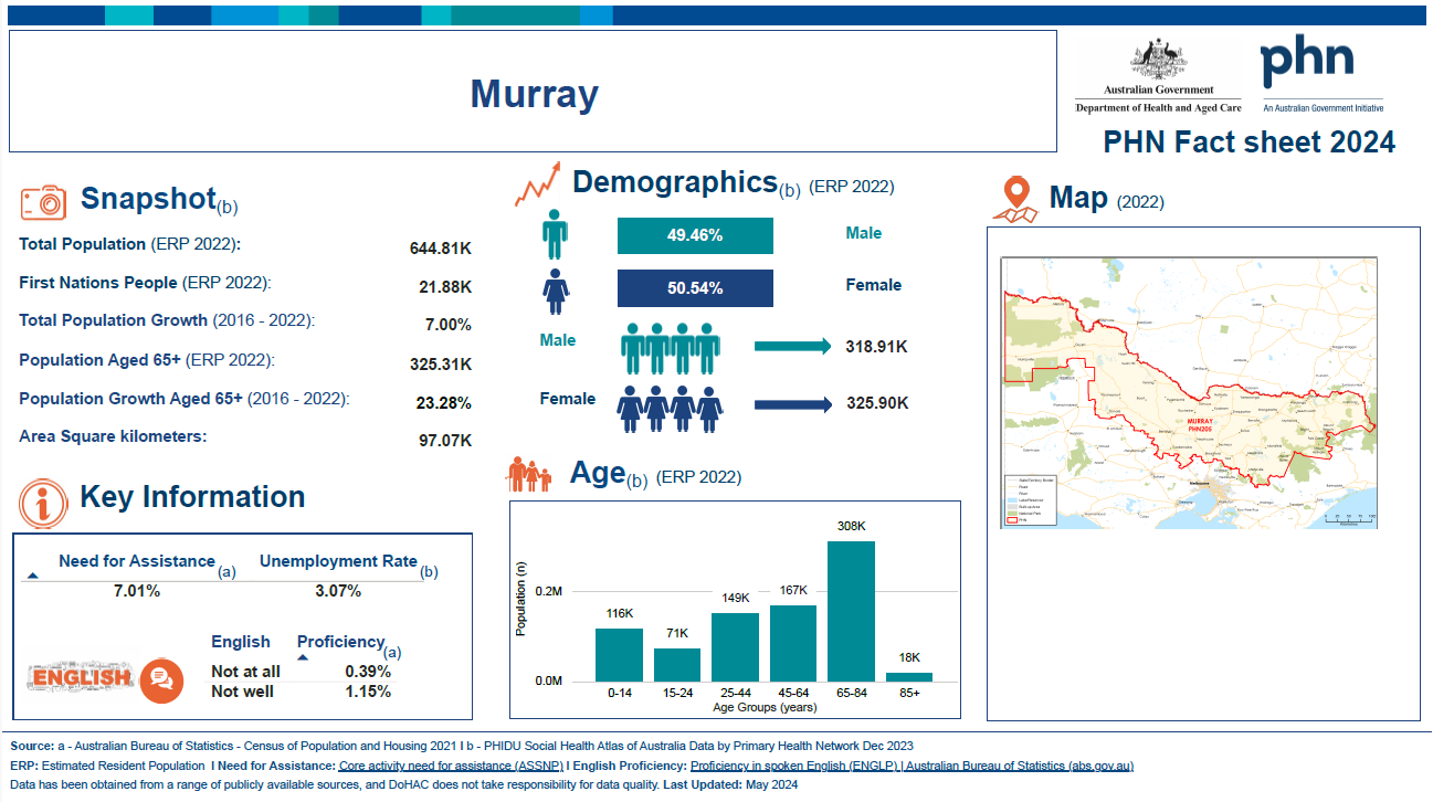
Murray (Vic) Primary Health Network (PHN) fact sheet
This fact sheet contains demographic information for the Murray (Vic) Primary Health Network (PHN). -
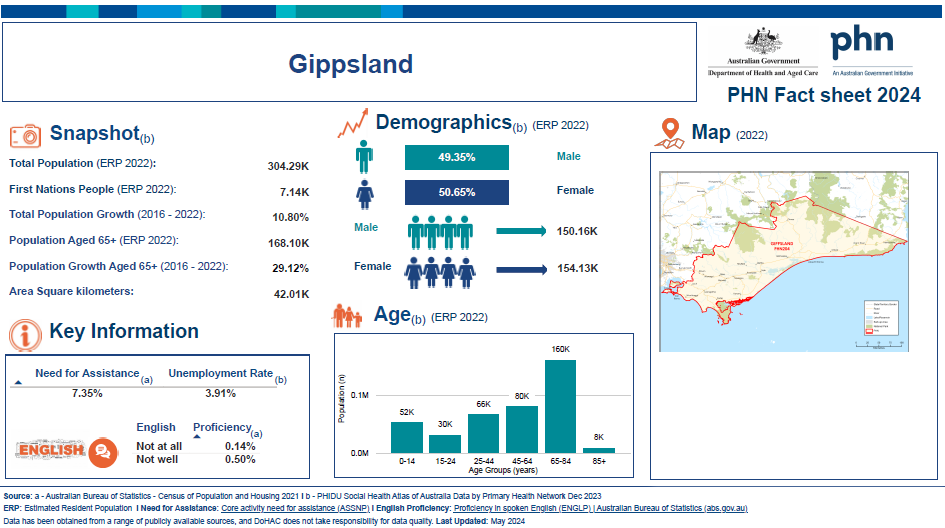
Gippsland (Vic) Primary Health Network (PHN) fact sheet
This fact sheet contains demographic information for the Gippsland (Vic) Primary Health Network (PHN). -
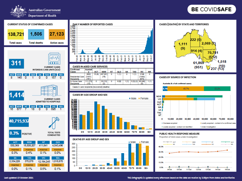
Coronavirus (COVID-19) at a glance – 15 October 2021
This infographic provides a quick view of the coronavirus (COVID-19) situation in Australia on 15 October 2021. -
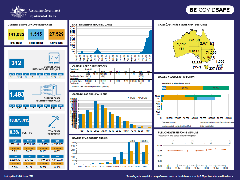
Coronavirus (COVID-19) at a glance – 16 October 2021
This infographic provides a quick view of the coronavirus (COVID-19) situation in Australia on 16 October 2021. -
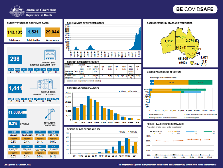
Coronavirus (COVID-19) at a glance – 17 October 2021
This infographic provides a quick view of the coronavirus (COVID-19) situation in Australia on 17 October 2021. -
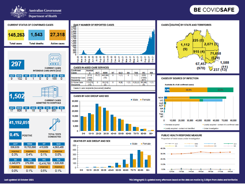
Coronavirus (COVID-19) at a glance – 18 October 2021
This infographic provides a quick view of the coronavirus (COVID-19) situation in Australia on 18 October 2021. -
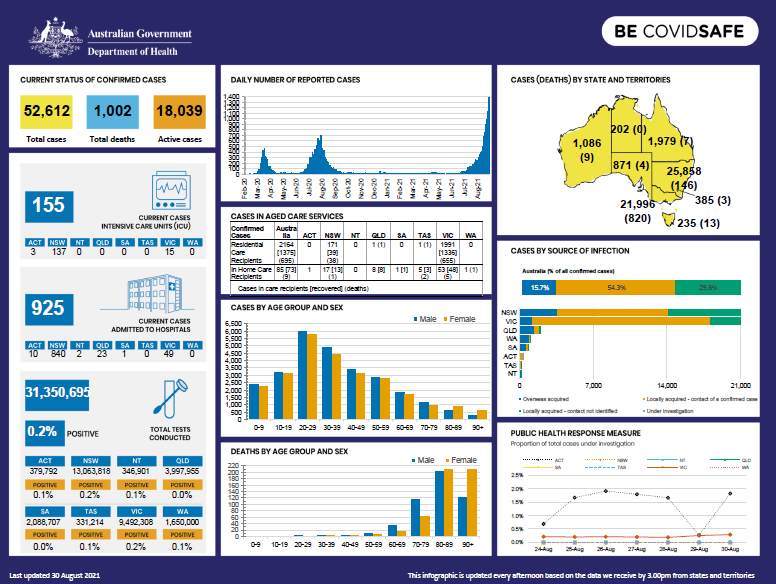
Coronavirus (COVID-19) at a glance – 30 August 2021
This infographic provides a quick view of the coronavirus (COVID-19) situation in Australia on 30 August 2021. -
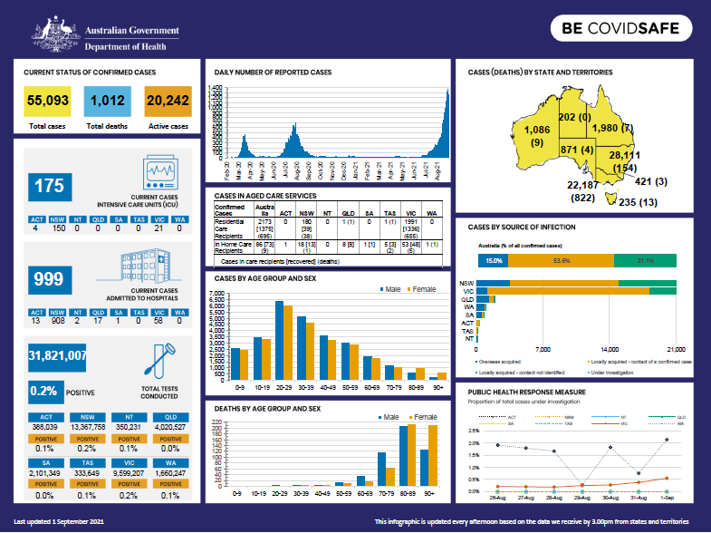
Coronavirus (COVID-19) at a glance – 1 September 2021
This infographic provides a quick view of the coronavirus (COVID-19) situation in Australia on 1 September 2021. -

Coronavirus (COVID-19) at a glance – 2 September 2021
This infographic provides a quick view of the coronavirus (COVID-19) situation in Australia on 2 September 2021. -
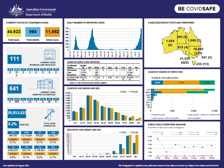
Coronavirus (COVID-19) at a glance – 23 August 2021
This infographic provides a quick view of the coronavirus (COVID-19) situation in Australia on 23 August 2021. -

Coronavirus (COVID-19) at a glance – 27 August 2021
This infographic provides a quick view of the coronavirus (COVID-19) situation in Australia on 27 August 2021. -
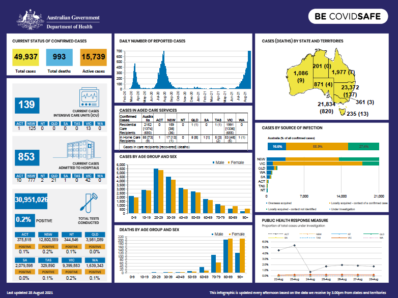
Coronavirus (COVID-19) at a glance – 28 August 2021
This infographic provides a quick view of the coronavirus (COVID-19) situation in Australia on 28 August 2021. -
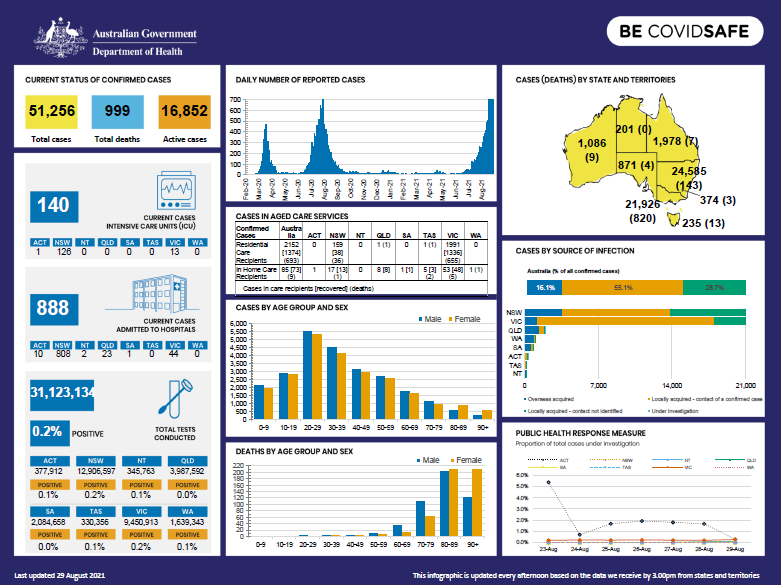
Coronavirus (COVID-19) at a glance – 29 August 2021
This infographic provides a quick view of the coronavirus (COVID-19) situation in Australia on 29 August 2021. -
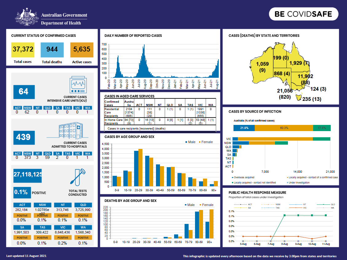
Coronavirus (COVID-19) at a glance – 11 August 2021
This infographic provides a quick view of the coronavirus (COVID-19) situation in Australia on 11 August 2021. -
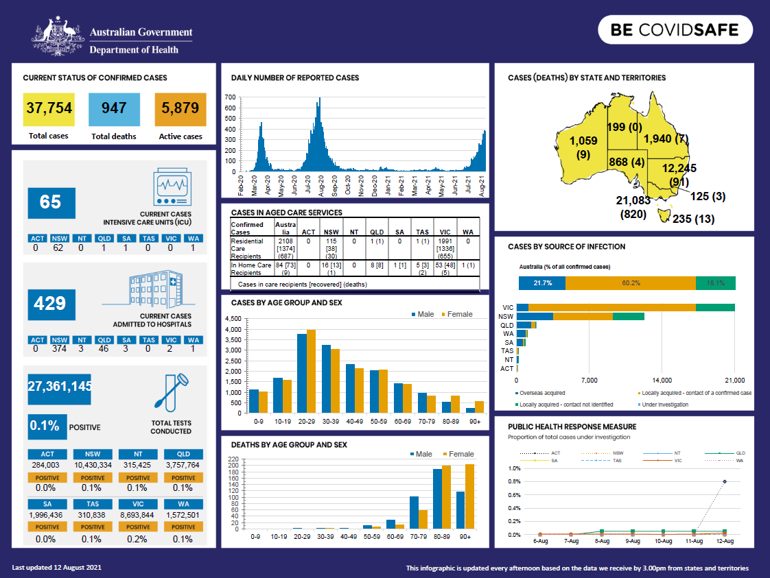
Coronavirus (COVID-19) at a glance – 12 August 2021
This infographic provides a quick view of the coronavirus (COVID-19) situation in Australia on 12 August 2021. -
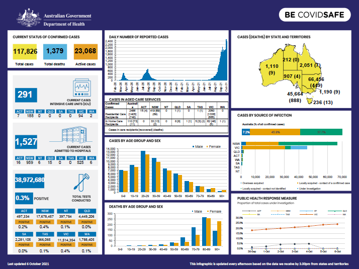
Coronavirus (COVID-19) at a glance – 6 October 2021
This infographic provides a quick view of the coronavirus (COVID-19) situation in Australia on 6 October 2021.