Filter results
You can narrow down the results using the filters
Audience
Topics
Our work
Diseases
11821 results
-
Carer Gateway service areas
A key element in implementing the new Integrated Carer Support Service (ICSS) is defining the service areas that the new Carer Gateway service providers will operate in from April 2020. -
Practice Incentives Program Quality Improvement Incentive fact sheet – What practices need to know
This fact sheet covers questions and answers for general practices under the Practice Incentives Program (PIP) Quality Improvement (QI) Incentive. -
Practice Incentives Program Quality Improvement Incentive fact sheet – ACCHS and other IAHP funded organisations
The fact sheet answers questions about the Practice Incentives Program (PIP) Quality Improvement (QI) Incentive for Aboriginal Community Controlled Health Services (ACCHS) and other organisations funded through the Indigenous Australians' Health Programme (IAHP). -
Financial Assistance to Support the Australian Medical Research and Innovation Priorities 2016–2018
This report presents the financial assistance provided from the MRFF Special Account during the period that the Australian Medical Research and Innovation Priorities 2016–2018 (2016–2018 Priorities) were active, specifically from November 2016 until November 2018. -
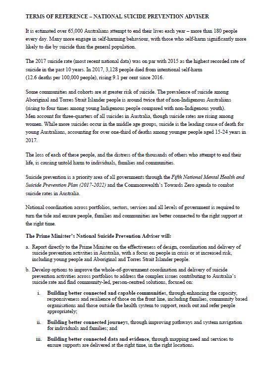
National Suicide Prevention Adviser terms of reference
These terms of reference outline what the National Suicide Prevention Adviser will do, and timeframes for deliverables. -
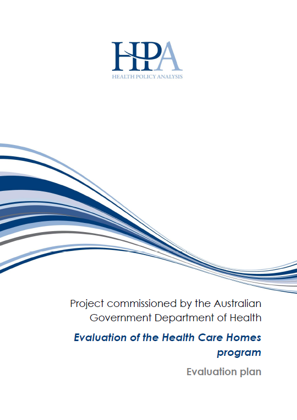
Evaluation of the Health Care Homes program – Evaluation plan
This evaluation plan specifies the design of the evaluation of the Health Care Homes trial, including questions to be answered, methods to be used, measures to show changes, sources of data, and how the statistical and qualitative analysis will be done. -
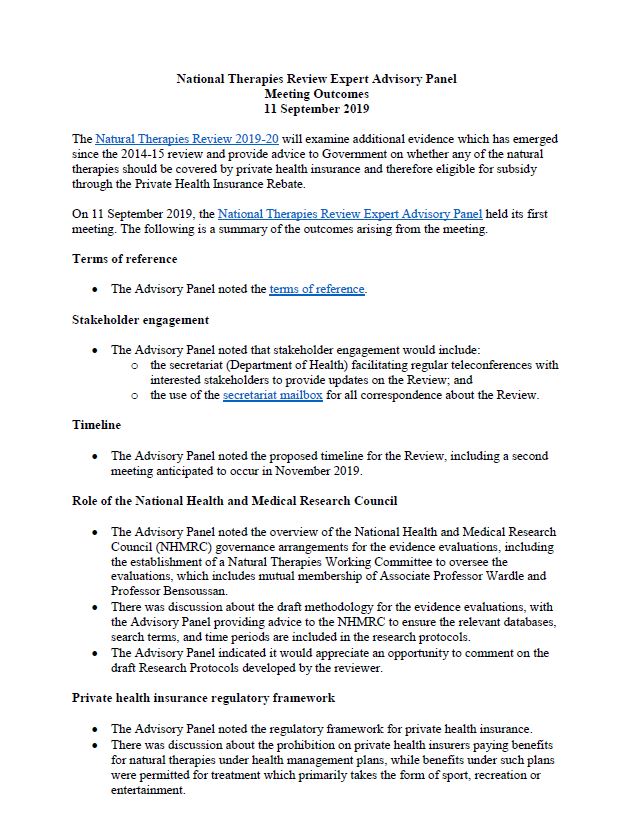
NTREAP meeting outcomes – 11 September 2019
Natural Therapies Review Expert Advisory Panel (NTREAP) meeting outcomes for 11 September 2019 meeting. -

BreastScreen Australia Clinical Advice
Expert clinical advice is provided to BreastScreen Australia about clinical issues. -
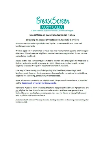
BreastScreen Australia policies
The BreastScreen Australia Program is supported by a number of frameworks and strategies. They guide how the program is delivered and make sure that high standards are maintained and best practice followed. -
Australian national guidelines for the management of healthcare workers living with, or exposed to, bloodborne viruses
The guidelines contain expert consensus on the evidence in relation to healthcare workers and their bloodborne virus (BBV) status. Recommendations include measures related to preventing transmission, managing and treating BBV in healthcare workers. -

Growth Aged Care Planning Regions and Service Types 2019–20
This document shows priority areas of growth for Commonwealth Home Support Programme (CHSP) services in each region. -

National Health Genomics Policy Framework
The National Health Genomics Policy Framework provides direction for governments in Australia to integrate genomics into our health system. It uses an agreed high-level national approach to policy, regulatory and investment decision-making for genomics. -
National Health Genomics Policy Framework 2018–2021 – Supplementary information
This document explains why we consider the strategic areas for action identified in the National Health Genomics Policy Framework to be a priority. It also provides background for readers who are less familiar with genomics. -
National Health Genomics Policy Framework 2018–2021 – Implementation plan
This implementation plan describes actions that will support Australia achieving the goals of the National Health Genomics Policy Framework. It includes 28 actions that will allow governments to prioritise activities and address current and emerging issues. -
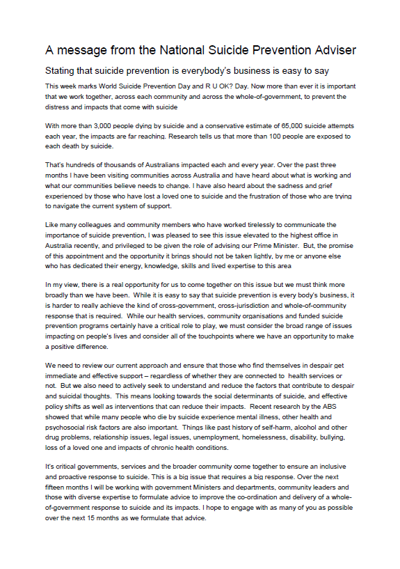
Stating that suicide prevention is everybody’s business is easy to say
A message from the Prime Minister's National Suicide Prevention Adviser, Ms Christine Morgan, for World Suicide Prevention Day 2019. -
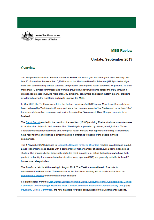
September 2019 update – MBS Review
This newsletter outlines recent changes to the Medicare Benefits Schedule (MBS) as a result of the MBS Review. -
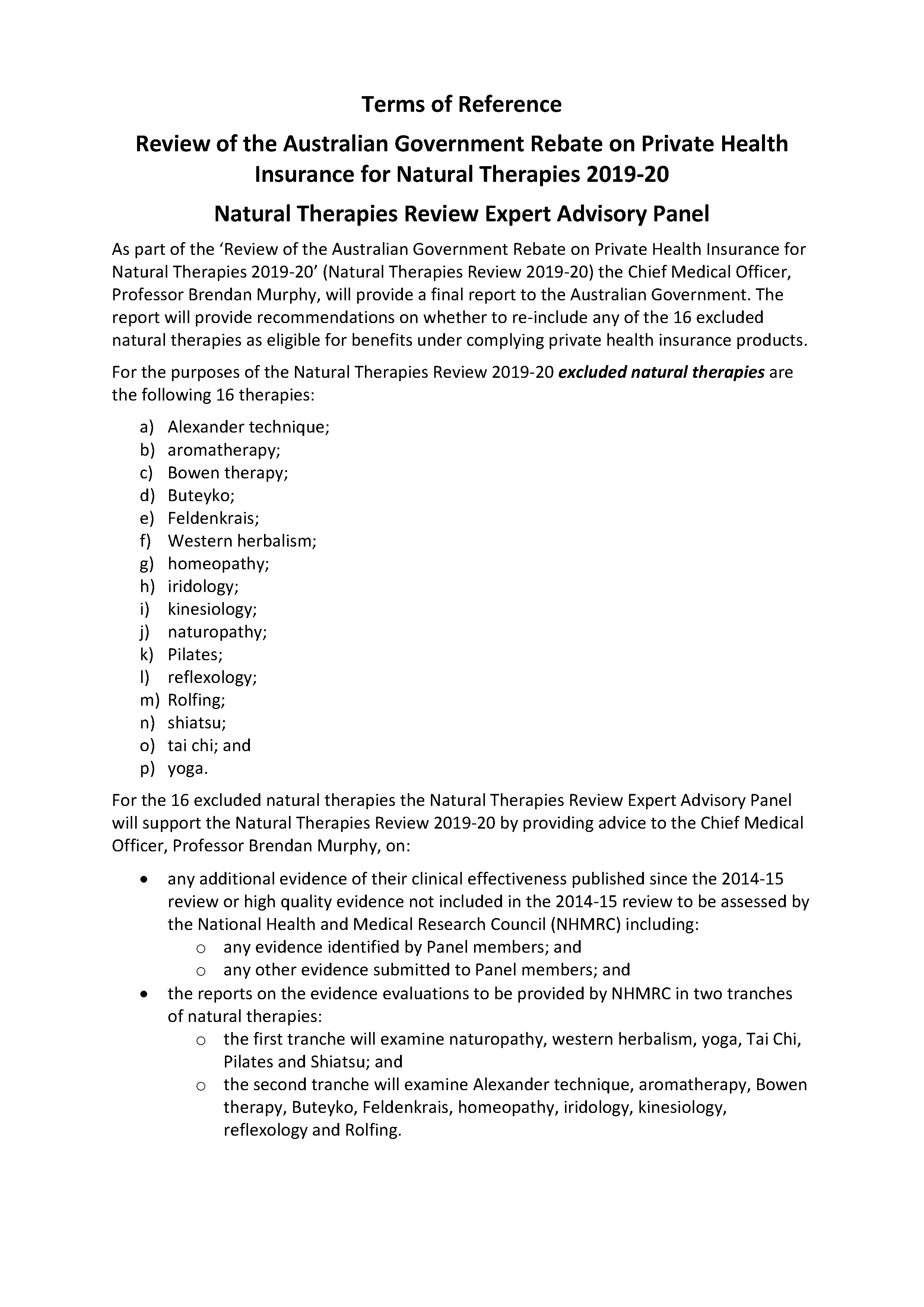
Natural Therapies Review Expert Advisory Panel — Terms of Reference
The Terms of Reference for the Natural Therapies Review Expert Advisory Panel (NTREAP). -
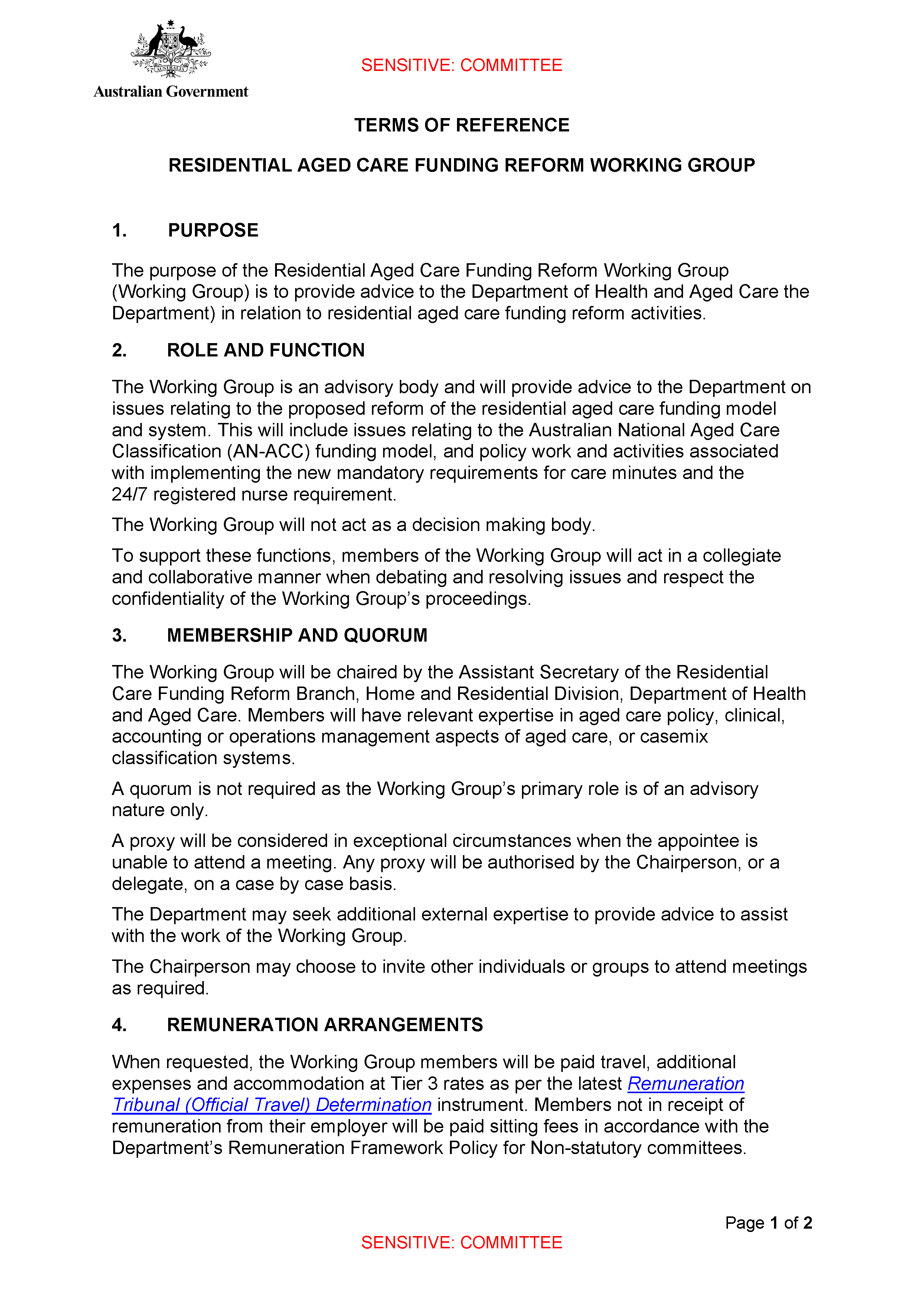
Residential Aged Care (RAC) Funding Reform Working Group Terms of Reference
The Terms of Reference for the RAC Funding Reform Working Group. -

Australian Trachoma Surveillance Report 2018
Trachoma is the world’s leading infectious cause of preventable blindness. In Australia, it affects mostly Aboriginal and Torres Strait Islander people. This document reports on the prevalence of trachoma in Australia in 2018. -
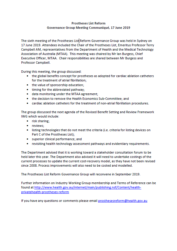
Prostheses List Reform Governance Group meeting communiques
Communiques for the Prostheses List Reform Governance Group meetings. -
National Strategic Action Plan for Macular Disease
The National Strategic Action Plan for Macular Disease proposes a national response to macular disease across all levels of government in Australia. It recommends action in 4 major areas. -
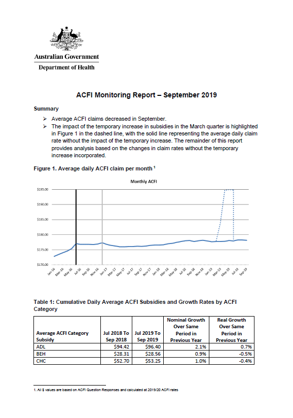
Aged care funding instrument (ACFI) monitoring report – September 2019
This report shows the monthly growth in ACFI subsidies compared to estimates for September 2019. -
Specialist Training Program operational framework
The operational framework outlines the aims, objectives, outcome parameters and governance of the Specialist Training Program, as well as updated information on funding activities and earlier application rounds. -
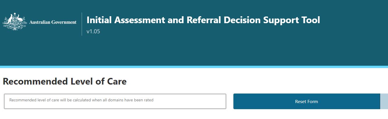
Initial Assessment and Referral Decision Support Tool – IAR Decision Support Tool
The Initial Assessment and Referral Decision Support Tool (IAR-DST) provides an evidence based tool for conducting initial assessment and referral of individuals presenting with mental health conditions in primary health care settings within Australia. -
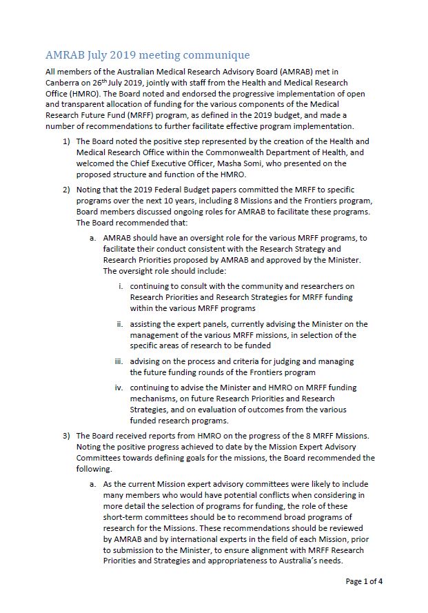
AMRAB communique – 26 July 2019
This communiqué summarises the meeting of the Australian Medical Research Advisory Board (AMRAB) held on 26 July 2019.