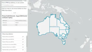
Use this tool to find each PHN's boundary and contact information, by clicking on the map, or by selecting:
- your location – once you give permission, the tool will automatically detect your location and PHN
- address – start entering the address, then select the correct address from the drop-down menu.
You can drag or zoom in or out on the map using the on-screen control or the scroll wheel on your mouse while holding the ctrl key.
You can overlap this with:
- federal electorates
- local government areas
- statistical area 3 (SA3) regions
- Modified Monash Model
- PHN boundaries.
Select the check boxes to display any of the above boundaries. Use the accordion to display the legend.
The information window displays the PHN's:
- PHN name
- PHN Code
- jurisdiction (state or territory)
- service name
- physical address
- postal address
- contact details
- website link.
Due to the large amount of data for some regions, please allow some time for the information to load.
Resource published:
Last updated: