Filter results
You can narrow down the results using the filters
Audience
Topics
Our work
Diseases
11794 results
-
Nepean Blue Mountains (NSW) Primary Health Network (PHN) map – Modified Monash Model (MMM) remoteness area
This map shows the Modified Monash Model remoteness area classifications of the Nepean Blue Mountains (NSW) Primary Health Network. -

Nepean Blue Mountains (NSW) Primary Health Network (PHN) map – socioeconomic disadvantage
This map shows the most socioeconomically disadvantaged areas within the Nepean Blue Mountains (NSW) Primary Health Network. -

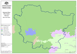
Nepean Blue Mountains (NSW) Primary Health Network (PHN) map – topographic
This map shows the geographical area of the Nepean Blue Mountains (NSW) Primary Health Network. -

Northern Territory (NT) Primary Health Network (PHN) map – Modified Monash Model (MMM) remoteness area
This map shows the Modified Monash Model remoteness area classifications of the Northern Territory Primary Health Network. -

Northern Territory (NT) Primary Health Network (PHN) map – socioeconomic disadvantage
This map shows the most socioeconomically disadvantaged areas within the Northern Territory Primary Health Network. -

Northern Territory (NT) Primary Health Network (PHN) map – topographic
This map shows the geographical area of the Northern Territory Primary Health Network. -
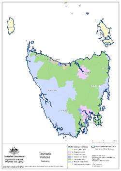
Tasmania Primary Health Network (PHN) map – Modified Monash Model (MMM) remoteness area
This map shows the Modified Monash Model remoteness area classifications of the Tasmania Primary Health Network. -

Tasmania Primary Health Network (PHN) map – socioeconomic disadvantage
This map shows the most socioeconomically disadvantaged areas within the Tasmania Primary Health Network. -

Tasmania Primary Health Network (PHN) map – topographic
This map shows the geographical area of the Tasmania Primary Health Network. -
Perth North (WA) Primary Health Network (PHN) map – Modified Monash Model (MMM) remoteness area
This map shows the Modified Monash Model remoteness area classifications of the Perth North (WA) Primary Health Network. -

Perth North (WA) Primary Health Network (PHN) map – socioeconomic disadvantage
This map shows the most socioeconomically disadvantaged areas within the Perth North (WA) Primary Health Network. -

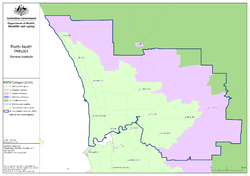
Perth North (WA) Primary Health Network (PHN) map – topographic
This map shows the geographical area of the Perth North (WA) Primary Health Network. -
Perth South (WA) Primary Health Network (PHN) map – Modified Monash Model (MMM) remoteness area
This map shows the Modified Monash Model remoteness area classifications of the Perth South (WA) Primary Health Network. -

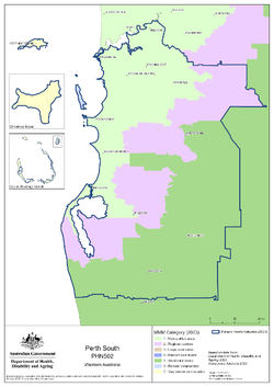
Perth South (WA) Primary Health Network (PHN) map – socioeconomic disadvantage
This map shows the most socioeconomically disadvantaged areas within the Perth South (WA) Primary Health Network. -
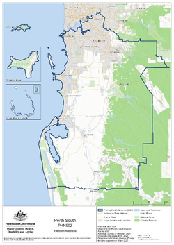
Perth South (WA) Primary Health Network (PHN) map – topographic
This map shows the geographical area of the Perth South (WA) Primary Health Network. -
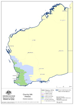
Country Western Australia Primary Health Network (PHN) map – Modified Monash Model (MMM) remoteness area
This map shows the Modified Monash Model remoteness area classifications of the Country Western Australia Primary Health Network. -

Country Western Australia Primary Health Network (PHN) map – socioeconomic disadvantage
This map shows the most socioeconomically disadvantaged areas within the Country Western Australia Primary Health Network. -

Country Western Australia Primary Health Network (PHN) map – topographic
This map shows the geographical area of the Country Western Australia Primary Health Network. -

Country South Australia Primary Health Network (PHN) map – Modified Monash Model (MMM) remoteness area
This map shows the Modified Monash Model remoteness area classifications of the Country South Australia Primary Health Network. -

Country South Australia Primary Health Network (PHN) map – socioeconomic disadvantage
This map shows the most socioeconomically disadvantaged areas within the Country South Australia Primary Health Network. -

Country South Australia Primary Health Network (PHN) map – topographic
This map shows the geographical area of the Country South Australia Primary Health Network. -
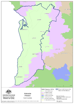
Adelaide (SA) Primary Health Network (PHN) map – Modified Monash Model (MMM) remoteness area
This map shows the Modified Monash Model remoteness area classifications of the Adelaide (SA) Primary Health Network. -

Adelaide (SA) Primary Health Network (PHN) map – socioeconomic disadvantage
This map shows the most socioeconomically disadvantaged areas within the Adelaide (SA) Primary Health Network. -

Adelaide (SA) Primary Health Network (PHN) map – topographic
This map shows the geographical area of the Adelaide (SA) Primary Health Network. -
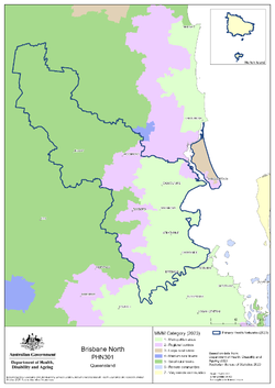
Brisbane North (Qld) Primary Health Network (PHN) map – Modified Monash Model (MMM) remoteness area
This map shows the Modified Monash Model remoteness area classifications of the Brisbane North (Qld) Primary Health Network.