Filter results
You can narrow down the results using the filters
Audience
Topics
Our work
Diseases
11796 results
-
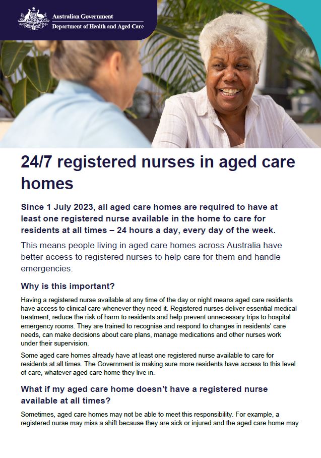
24/7 registered nurses in aged care homes
This fact sheet helps older people, their families and carers understand the 24/7 registered nurse requirement for approved residential aged care. -

Thriving Kids Advisory Group communique – September 2025
This communique is published following each meeting of the Thriving Kids Advisory Group. It summarises the meeting discussions and outcomes. -

Australian Capital Territory Primary Health Networks (PHN) boundary map
This map shows the boundaries for the Australian Capital Territory Health Network (PHN). Boundaries as at August 2023. -

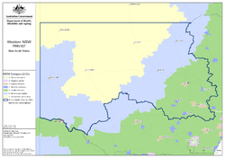
Northern Territory Primary Health Networks (PHN) boundary map
This map shows the boundaries for the Northern Territory Health Network (PHN). -

Australian Capital Territory (ACT) Primary Health Network (PHN) map – Modified Monash Model (MMM) remoteness area
This map shows the Modified Monash Model remoteness area classifications of the Australian Capital Territory Primary Health Network. -

Australian Capital Territory (ACT) Primary Health Network (PHN) map – socioeconomic disadvantage
This map shows the most socioeconomically disadvantaged areas within the Australian Capital Territory Primary Health Network. -

Australian Capital Territory (ACT) Primary Health Network (PHN) map – topographic
This map shows the geographical area of the Australian Capital Territory Primary Health Network. -
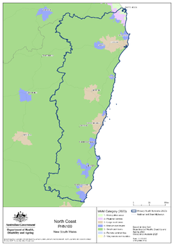
North Coast (NSW) Primary Health Network (PHN) map – Modified Monash Model (MMM) remoteness area
This map shows the Modified Monash Model remoteness area classifications of the North Coast (NSW) Primary Health Network. -

North Coast (NSW) Primary Health Network (PHN) map – socioeconomic disadvantage
This map shows the most socioeconomically disadvantaged areas within the North Coast (NSW) Primary Health Network. -

North Coast (NSW) Primary Health Network (PHN) map – topographic
This map shows the geographical area of the North Coast (NSW) Primary Health Network. -

Northern Sydney (NSW) Primary Health Network (PHN) map – Modified Monash Model (MMM) remoteness area
This map shows the Modified Monash Model remoteness area classifications of the Northern Sydney (NSW) Primary Health Network. -

Northern Sydney (NSW) Primary Health Network (PHN) map – socioeconomic disadvantage
This map shows the most socioeconomically disadvantaged areas within the Northern Sydney (NSW) Primary Health Network. -
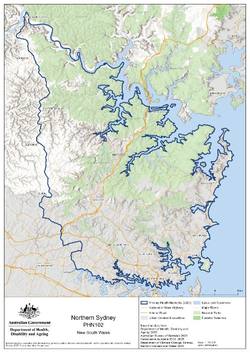
Northern Sydney (NSW) Primary Health Network (PHN) map – topographic
This map shows the geographical area of the Northern Sydney (NSW) Primary Health Network. -
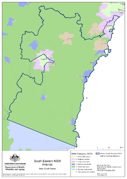
South Eastern New South Wales Primary Health Network (PHN) map – Modified Monash Model (MMM) remoteness area
This map shows the Modified Monash Model remoteness area classifications of the South Eastern New South Wales Primary Health Network. -

South Eastern New South Wales Primary Health Network (PHN) map – socioeconomic disadvantage
This map shows the most socioeconomically disadvantaged areas within the South Eastern New South Wales Primary Health Network. -

South Eastern New South Wales Primary Health Network (PHN) map – topographic
This map shows the geographical area of the South Eastern New South Wales Primary Health Network. -

South Western Sydney (NSW) Primary Health Network (PHN) map – Modified Monash Model (MMM) remoteness area
This map shows the Modified Monash Model remoteness area classifications of the South Western Sydney (NSW) Primary Health Network. -

South Western Sydney (NSW) Primary Health Network (PHN) map – socioeconomic disadvantage
This map shows the most socioeconomically disadvantaged areas within the South Western Sydney (NSW) Primary Health Network. -

South Western Sydney (NSW) Primary Health Network (PHN) map – topographic
This map shows the geographical area of the South Western Sydney (NSW) Primary Health Network. -

Western New South Wales Primary Health Network (PHN) map – socioeconomic disadvantage
This map shows the most socioeconomically disadvantaged areas within the Western New South Wales Primary Health Network. -
Western New South Wales Primary Health Network (PHN) map – Modified Monash Model (MMM) remoteness area
This map shows the Modified Monash Model remoteness area classifications of the Western New South Wales Primary Health Network. -

Western New South Wales Primary Health Network (PHN) map – topographic
This map shows the geographical area of the Western New South Wales Primary Health Network. -
Western Sydney (NSW) Primary Health Network (PHN) map – Modified Monash Model (MMM) remoteness area
This map shows the Modified Monash Model remoteness area classifications of the Western Sydney (NSW) Primary Health Network. -

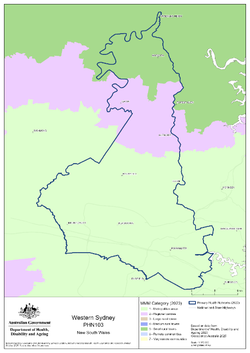
Western Sydney (NSW) Primary Health Network (PHN) map – socioeconomic disadvantage
This map shows the most socioeconomically disadvantaged areas within the Western Sydney (NSW) Primary Health Network. -
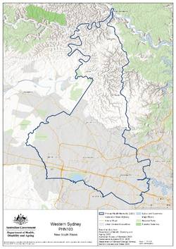
Western Sydney (NSW) Primary Health Network (PHN) map – topographic
This map shows the geographical area of the Western Sydney (NSW) Primary Health Network.