Filter results
You can narrow down the results using the filters
Audience
Topics
Our work
Diseases
11818 results
-
NMHWS taskforce meeting communique – 8 and 11 September 2020
This communique summarises the 7th and 8th meetings of the National Mental Health Workforce Strategy taskforce (NMHWS) held by video conference on 8 and 11 September 2020. -

Coronavirus (COVID-19) at a glance – 30 August 2020
This infographic provides a quick view of the coronavirus (COVID-19) situation in Australia on 30 August 2020. -

Coronavirus (COVID-19) at a glance – 29 August 2020
This infographic provides a quick view of the coronavirus (COVID-19) situation in Australia on 29 August 2020. -
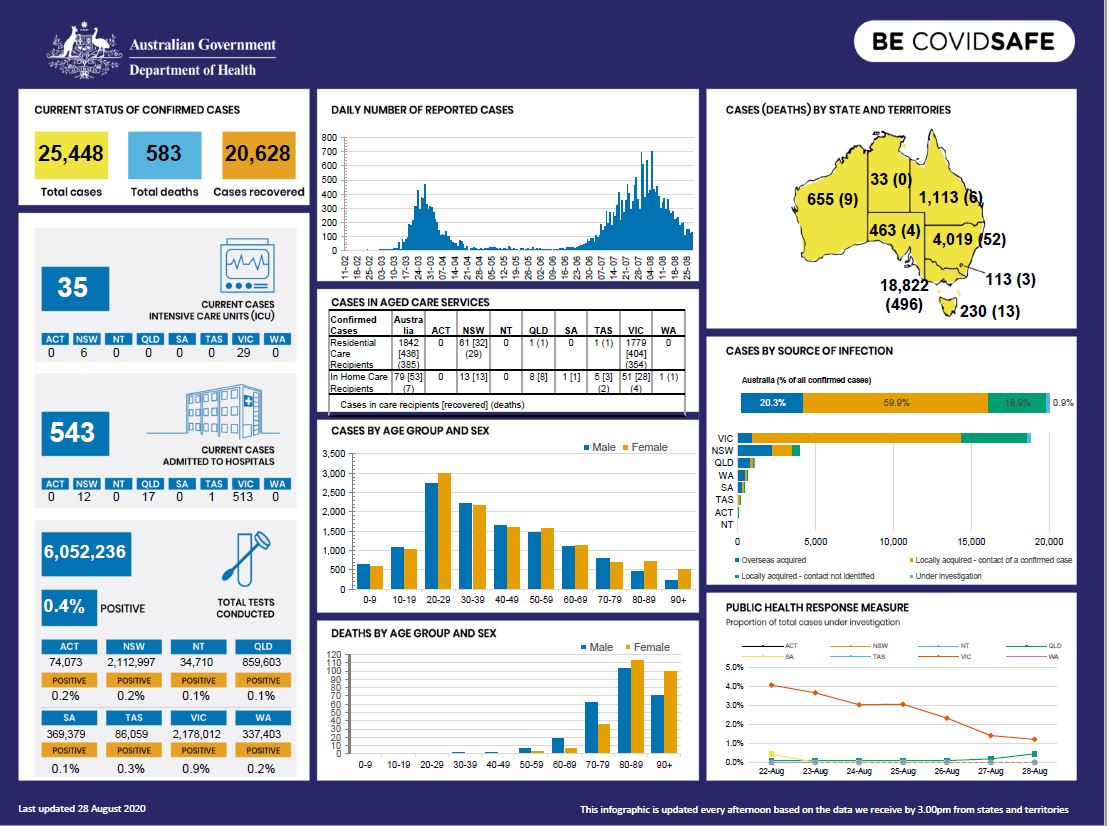
Coronavirus (COVID-19) at a glance – 28 August 2020
This infographic provides a quick view of the coronavirus (COVID-19) situation in Australia on 28 August 2020. -
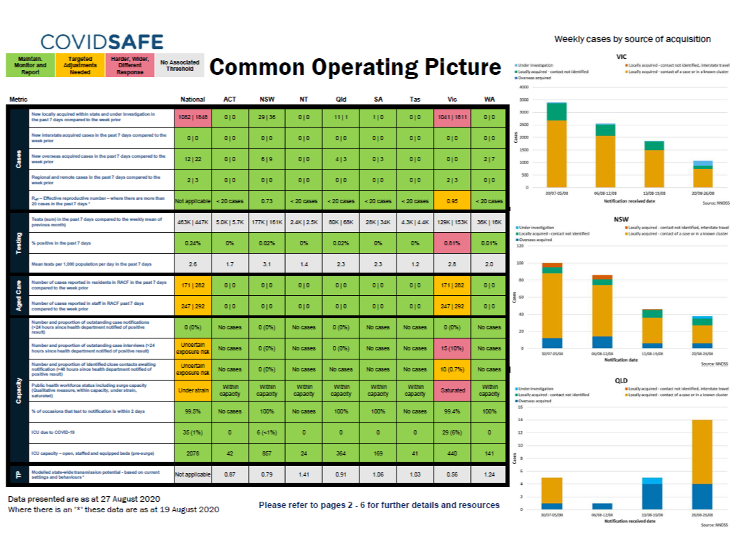
Coronavirus (COVID-19) common operating picture – 27 August 2020
This infographic provides a weekly traffic light report of the coronavirus (COVID-19) situation across Australia issued on 27 August 2020. -
Government response to the NDIS Act review
The Australian Government welcomes the 2019 review of the National Disability Insurance Scheme Act 2013 (the NDIS Act) report completed by Mr David Tune AO PSM (the Report). -

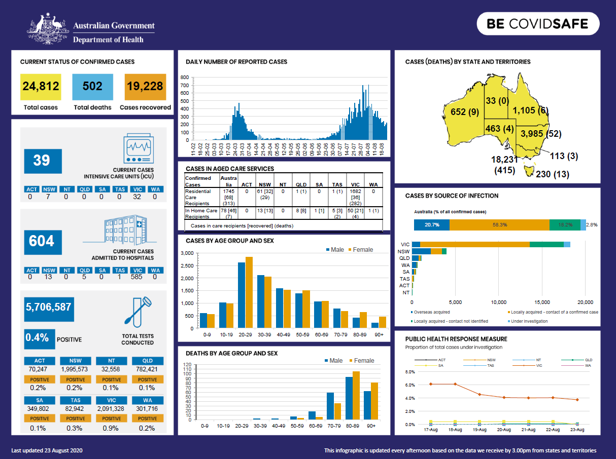
Coronavirus (COVID-19) at a glance – 27 August 2020
This infographic provides a quick view of the coronavirus (COVID-19) situation in Australia on 27 August 2020. -

Coronavirus (COVID-19) at a glance – 26 August 2020
This infographic provides a quick view of the coronavirus (COVID-19) situation in Australia on 26 August 2020. -
Practice Incentives Program Quality Improvement Incentive – Data privacy and security review
This document covers the findings of a review of data collected, held and transferred as part of the Practice Incentive Program (PIP) Quality Improvement (QI) Incentive. -

Coronavirus (COVID-19) – Review of Dorothy Henderson Lodge COVID-19 Outbreak
An independent review into the COVID-19 outbreak at Dorothy Henderson Lodge in New South Wales was commissioned by the Department of Health to understand what occurred and what could be learned from the experience. The review was undertaken by Professor Lyn Gilbert. -

Coronavirus (COVID-19) at a glance – 25 August 2020
This infographic provides a quick view of the coronavirus (COVID-19) situation in Australia on 25 August 2020. -

Advisory Committee for the COVID-19 Response for People with Disability – Meeting key outcomes 25 August 2020
The communique is for the meetings of the Advisory Committee on Health Emergency Response to Coronavirus (COVID-19) for People with Disability on 25 August 2020. -

Coronavirus (COVID-19) – Newmarch House COVID-19 Outbreak Independent Review
An independent review into the COVID-19 outbreak at Newmarch House was commissioned by the Department of Health to understand what occurred and what could be learned from the experience. The review was undertaken by Professor Lyn Gilbert and Adjunct Professor Alan Lilly. -
Terms of reference – Aged Care Advisory Group
The Aged Care Advisory Group is a permanent advisory group under the auspices of the Australian Health Protection Committee (AHPC). It advises on matters relevant to health protection in the aged care sector. -

Aged care facilities – initial communications
This printable fact sheet from the Victorian Aged Care Response Centre gives residential aged care facilities (RACFs) guidance on initial communications with residents, nominated representatives, families and staff, in the event of a COVID-19 outbreak. -

Aged care facilities – ongoing communications
This printable fact sheet from the Victorian Aged Care Response Centre gives residential aged care facilities (RACFs) guidance on ongoing communications with residents, nominated representatives, families and staff, in the event of a COVID-19 outbreak. -

Aged care facilities – contact details template
This spreadsheet from the Victorian Aged Care Response Centre is a template for residential aged care facilities to use when creating a list of contacts for all residents. -

Coronavirus (COVID-19) at a glance – 24 August 2020
This infographic provides a quick view of the coronavirus (COVID-19) situation in Australia on 24 August 2020. -
Coronavirus (COVID-19) at a glance – 23 August 2020
This infographic provides a quick view of the coronavirus (COVID-19) situation in Australia on 23 August 2020. -

Coronavirus (COVID-19) at a glance – 22 August 2020
This infographic provides a quick view of the coronavirus (COVID-19) situation in Australia on 22 August 2020. -
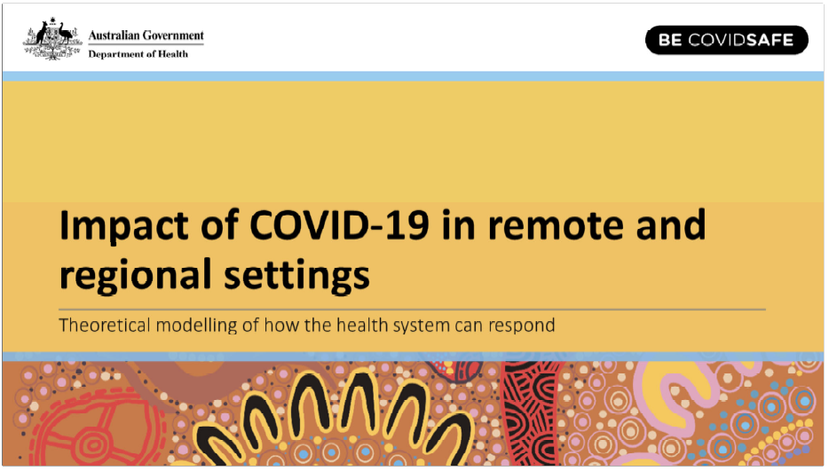
Impact of COVID-19 in remote and regional settings
This presentation includes an introduction to modelling, how COVID-19 could spread in an Aboriginal and Torres Strait Islander community, and what individuals and communities can do to try and stop the spread of COVID-19. -
Guide to the Establishment of an Aged Care Health Emergency Response Operations Centre
The Australian Government’s Guide to Establishment of an Aged Care Health Emergency Response Operations Centre complements existing emergency response planning for the aged care sector. -
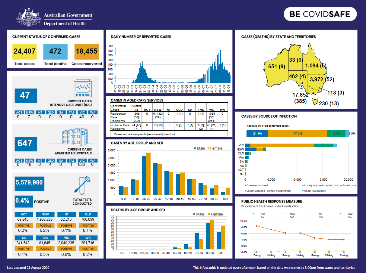
Coronavirus (COVID-19) at a glance – 21 August 2020
This infographic provides a quick view of the coronavirus (COVID-19) situation in Australia on 21 August 2020. -

Coronavirus (COVID-19) at a glance – 20 August 2020
This infographic provides a quick view of the coronavirus (COVID-19) situation in Australia on 20 August 2020. -
Australian Government Response to the Joint Standing Committee on the NDIS Report into Supported Independent Living (SIL)
The Australian Government welcomes the Committee’s report and recognises the role of the Committee in improving participant experience with the NDIS and the current processes and oversight of the scheme by the National Disability Insurance Agency (NDIA)