Filter results
You can narrow down the results using the filters
Audience
Topics
Our work
Diseases
11620 results
-

North Western Melbourne (Vic) Primary Health Network (PHN) map – topographic
This map shows the geographical area of the North Western Melbourne (Vic) Primary Health Network. -

South Eastern Melbourne (Vic) Primary Health Network (PHN) map – topographic
This map shows the geographical area of the South Eastern Melbourne (Vic) Primary Health Network. -

Western Victoria Primary Health Network (PHN) map – Modified Monash Model (MMM) remoteness area
This map shows the Modified Monash Model remoteness area classifications of the Western Victoria Primary Health Network. -

Western Victoria Primary Health Network (PHN) map – socioeconomic disadvantage
This map shows the most socioeconomically disadvantaged areas within the Western Victoria Primary Health Network. -
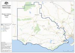
Western Victoria Primary Health Network (PHN) map – topographic
This map shows the geographical area of the Western Victoria Primary Health Network. -

Central Queensland, Wide Bay, Sunshine Coast Primary Health Network (PHN) map – socioeconomic disadvantage
This map shows the most socioeconomically disadvantaged areas within the Central Queensland, Wide Bay, Sunshine Coast Primary Health Network. -
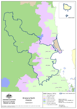
Brisbane North (Qld) Primary Health Network (PHN) map – Modified Monash Model (MMM) remoteness area
This map shows the Modified Monash Model remoteness area classifications of the Brisbane North (Qld) Primary Health Network. -

Brisbane South (Qld) Primary Health Network (PHN) map – Modified Monash Model (MMM) remoteness area
This map shows the Modified Monash Model remoteness area classifications of the Brisbane South (Qld) Primary Health Network. -

Brisbane North (Qld) Primary Health Network (PHN) map – socioeconomic disadvantage
This map shows the most socioeconomically disadvantaged areas within the Brisbane North (Qld) Primary Health Network. -

Brisbane South (Qld) Primary Health Network (PHN) map – socioeconomic disadvantage
This map shows the most socioeconomically disadvantaged areas within the Brisbane South (Qld) Primary Health Network. -

Central Queensland, Wide Bay, Sunshine Coast Primary Health Network (PHN) map – topographic
This map shows the geographical area of the Central Queensland, Wide Bay, Sunshine Coast Primary Health Network. -

Brisbane South (Qld) Primary Health Network (PHN) map – topographic
This map shows the geographical area of the Brisbane South (Qld) Primary Health Network. -

Central Queensland, Wide Bay, Sunshine Coast Primary Health Network (PHN) map – Modified Monash Model (MMM) remoteness area
This map shows the Modified Monash Model remoteness area classifications of the Central Queensland, Wide Bay, Sunshine Coast Primary Health Network. -

Darling Downs and West Moreton (Qld) Primary Health Network (PHN) map – socioeconomic disadvantage
This map shows the most socioeconomically disadvantaged areas within the Darling Downs and West Moreton (Qld) Primary Health Network. -
Gold Coast (Qld) Primary Health Network (PHN) map – Modified Monash Model (MMM) remoteness area
This map shows the Modified Monash Model remoteness area classifications of the Gold Coast (Qld) Primary Health Network. -

Gold Coast (Qld) Primary Health Network (PHN) map – socioeconomic disadvantage
This map shows the most socioeconomically disadvantaged areas within the Gold Coast (Qld) Primary Health Network. -

Darling Downs and West Moreton (Qld) Primary Health Network (PHN) map – topographic
This map shows the geographical area of the Darling Downs and West Moreton (Qld) Primary Health Network. -

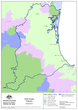
Gold Coast (Qld) Primary Health Network (PHN) map – topographic
This map shows the geographical area of the Gold Coast (Qld) Primary Health Network. -
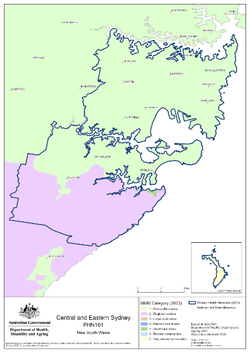
Central and Eastern Sydney (NSW) Primary Health Network (PHN) map – Modified Monash Model (MMM) remoteness area
This map shows the Modified Monash Model remoteness area classifications of the Central and Eastern Sydney (NSW) Primary Health Network. -

Hunter, New England and Central Coast (NSW) Primary Health Network (PHN) map – socioeconomic disadvantage
This map shows the most socioeconomically disadvantaged areas within the Hunter, New England and Central Coast (NSW) Primary Health Network. -

Central and Eastern Sydney (NSW) Primary Health Network (PHN) map – socioeconomic disadvantage
This map shows the most socioeconomically disadvantaged areas within the Central and Eastern Sydney (NSW) Primary Health Network. -

Hunter, New England and Central Coast (NSW) Primary Health Network (PHN) map – topographic
This map shows the geographical area of the Hunter, New England and Central Coast (NSW) Primary Health Network. -

Central and Eastern Sydney (NSW) Primary Health Network (PHN) map – topographic
This map shows the geographical area of the Central and Eastern Sydney (NSW) Primary Health Network. -
 59:38
59:38Aged Care Provider Requirements Search tool – Video
This is a recording of the Aged Care Provider Requirements Search tool webinar held on 16 September 2025. -
Government Provider Management System (GPMS) - Glossary
Defines key terms used across the Government Provider Management System (GPMS) portals and guidance materials, supporting clarity for aged care providers under the Aged Care Act 2024.