Filter results
You can narrow down the results using the filters
Audience
Topics
Our work
Diseases
11846 results
-
Life Saving Drugs Program – Pompe disease – Medicines review protocol
This final protocol describes the methodology reviewers will follow to assess use of Life Saving Drugs Program medicines for Pompe disease. -
Life Saving Drugs Program – Mucopolysaccharidosis type II (MPS II) – Medicines review protocol
This final protocol describes the methodology reviewers will follow to assess use of Life Saving Drugs Program medicines for MPS II. -
Life Saving Drugs Program – Paroxysmal nocturnal haemoglobinuria – Medicines review protocol
This final protocol describes the methodology reviewers will follow to assess use of Life Saving Drugs Program medicines for paroxysmal nocturnal haemoglobinuria. -
Stillbirth research and education
Australian Government response to the Senate Select Committee on Stillbirth Research and Education Report. -
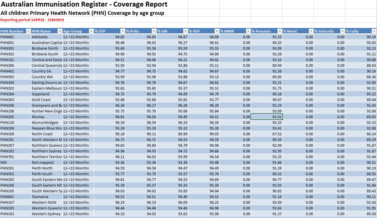
2019 PHN Childhood immunisation coverage data
The following spreadsheets provide quarterly 2019 data on childhood immunisation coverage by Primary Health Network (PHN) for all children and Aboriginal and Torres Strait Islander children. -
National Medical Workforce Strategy scoping framework
This framework focuses on identifying and understanding medical workforce issues that will benefit from national workforce planning. -
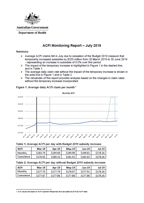
Aged care funding instrument (ACFI) monitoring report – July 2019
This report shows the monthly growth in ACFI subsidies compared to estimates for July 2019. -
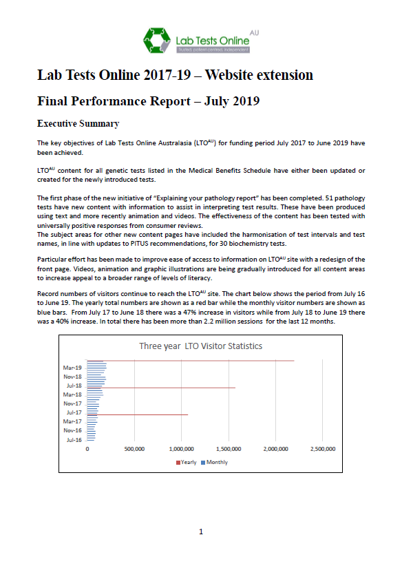
Quality Use of Pathology (QUP) Project Stream – Final report for the Lab Tests Online Australasia additions to support genetics, eHealth and outreach
This final report outlines the results of the Australasian Association of Clinical Biochemistry and Laboratory Medicine’s project to support genetics, eHealth and outreach. -
National Aged Care Mandatory Quality Indicator Program Manual 1.0
This version of the manual was in effect from 1 July 2019 to 30 June 2021. -
2016–17 Operations Report of the Aged Care Financing Authority (ACFA)
This is the fifth annual operations report for ACFA. It covers the period 1 July 2016 to 30 June 2017. -
2017–18 Operations Report of the Aged Care Financing Authority (ACFA)
This is the sixth annual operations report for ACFA. It covers the period 1 July 2017 to 30 June 2018. -

Sixth Report on the Funding and Financing of the Aged Care Sector – July 2018
This is the sixth annual report on funding and financing by the Aged Care Financing Authority (ACFA). It looks at the challenges facing the aged care sector in Australia and includes analysis of the data supplied by service providers in their 2016–17 financial reports.
-
Seventh Report on the Funding and Financing of the Aged Care Industry – July 2019
This is the seventh annual report on funding and financing by the Aged Care Financing Authority (ACFA). It looks at the challenges facing the aged care sector in Australia and includes analysis of the data supplied by service providers in their 2017–18 financial reports. -
Approved Private Emergency Department Program guidelines
These guidelines provide the background, principles, eligibility criteria and operational procedures of the program for participating hospitals. -
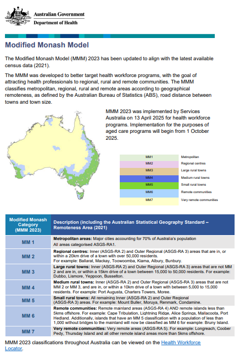
Modified Monash Model – fact sheet
Information about the Modified Monash Model geographical classification. -
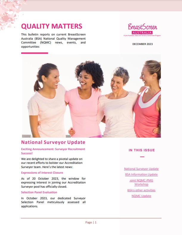
BreastScreen Australia – Quality matters bulletins
These bulletins report on current National Quality Management Committee (NQMC) news, events and opportunities for BreastScreen Australia Services. -
BreastScreen Australia accreditation
BreastScreen Australia Services and State Coordination Units (SCUs) must be accredited every 4 years. These resources are used in the accreditation process. -
Quality of Information and Guidance Industry Working Group Terms of Reference
This document sets out the roles, function, membership and operating guidelines of the Quality of Information and Guidance Industry Working Group. -
Health Budget 2019–20
The 2019–20 Budget was released on 2 April 2019. This collection includes all information related to the 2019–20 Health Portfolio Budget. -
National Aged Care Mandatory Quality Indicator Program Manual 2.0 – Part A
This version of the manual was in effect from 1 July 2021 to 31 March 2023. -
Streamlined Consumer Assessment for Aged Care Consultation – Summary Report of Key Insights
This report provides a summary of the key issues and feedback from the Streamlined Consumer Assessment for Aged Care Consultation. -
Budget 2019–20: More Choices for a Longer Life – enhanced home care support for veterans
This Budget fact sheet outlines how the Government will increase the supplement paid to veterans with a mental health condition related to their service, who are receiving a home care package. -
Budget 2019–20: Guaranteeing Medicare and access to medicines
This set of 2019–20 Health Portfolio Budget fact sheets contain information related to Medicare and access to medicines. -
Budget 2019–20: Supporting our hospitals
This set of 2019–20 Health Portfolio Budget fact sheets contain information related to supporting our hospitals. -
Budget 2019–20: Prioritising mental health, preventive health and sport
This set of 2019–20 Health Portfolio Budget fact sheets contain information related to prioritising mental health, preventive health and sport.