Filter results
You can narrow down the results using the filters
Audience
Topics
Our work
Diseases
11351 results
-
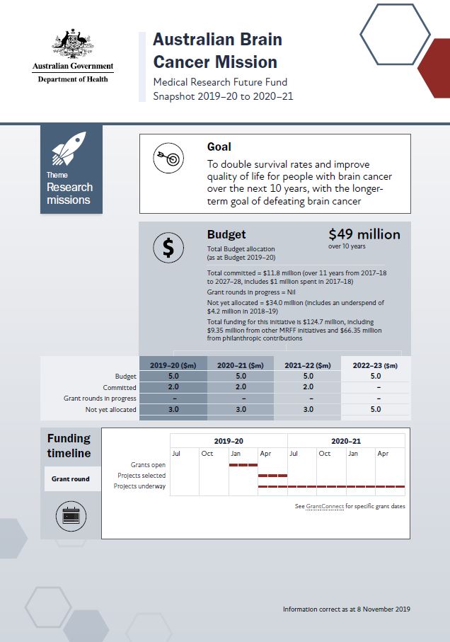
MRFF snapshot – Australian Brain Cancer Mission
This snapshot shows this Mission at a glance. It includes budgets, early funding priorities and grant timelines, as of November 2019. Researchers and other stakeholders can use it to plan for upcoming opportunities and see how the Mission will be established, expanded and embedded over time. -
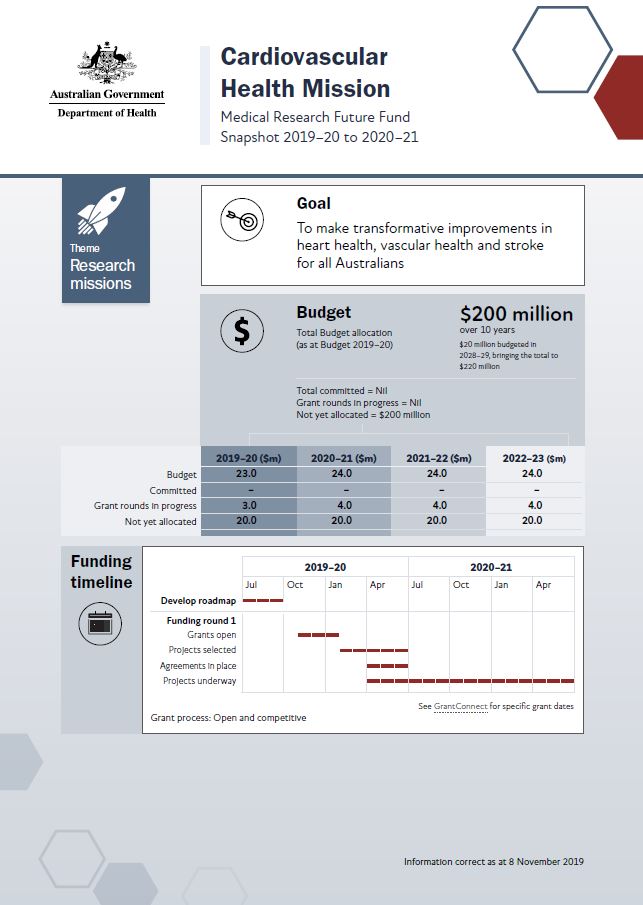
MRFF snapshot – Cardiovascular Health Mission
This snapshot shows this Mission at a glance. It includes budgets, early funding priorities and grant timelines, as at November 2019. Researchers and other stakeholders can use it to plan for upcoming opportunities and see how the Mission will be established, expanded and embedded over time. -
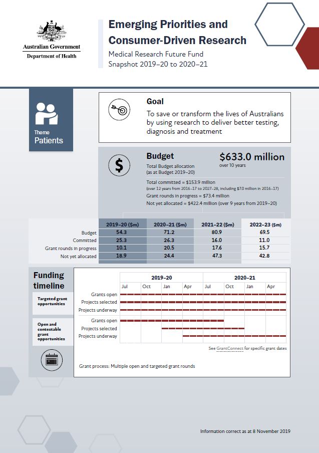
MRFF snapshot – Emerging Priorities and Consumer-Driven Research
This snapshot shows this initiative at a glance. It includes budgets, early funding priorities and grant timelines, as at November 2019. Researchers and other stakeholders can use it to plan for upcoming opportunities and see how the initiative will be established, expanded and embedded over time. -
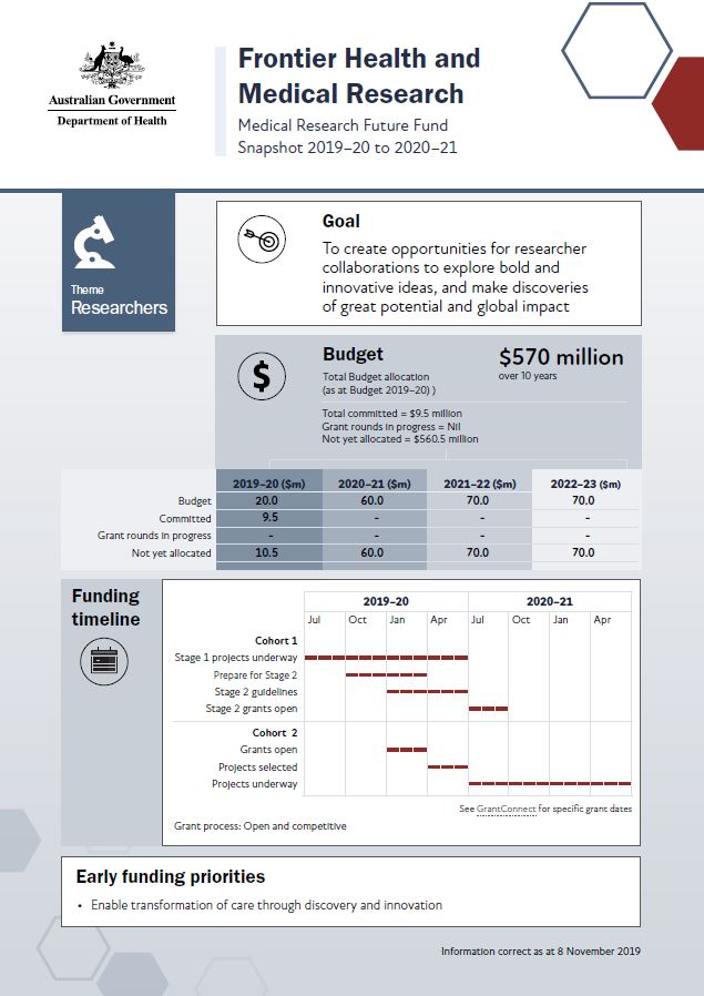
MRFF snapshot – Frontier Health and Medical Research
This snapshot shows this initiative at a glance. It includes budgets, early funding priorities and grant timelines, as of November 2019. Researchers and other stakeholders can use it to plan for upcoming opportunities and see how the initiative will be established, expanded and embedded over time. -
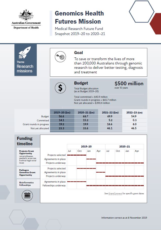
MRFF snapshot – Genomics Health Futures Mission
This snapshot shows this Mission at a glance. It includes budgets, early funding priorities and grant timelines, as at November 2019. Researchers and other stakeholders can use it to plan for upcoming opportunities and see how the Mission will be established, expanded and embedded over time. -
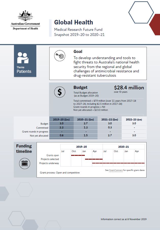
MRFF snapshot – Global Health
This snapshot shows this initiative at a glance. It includes budgets, early funding priorities and grant timelines, as at November 2019. Researchers and other stakeholders can use it to plan for upcoming opportunities and see how the initiative will be established, expanded and embedded over time. -
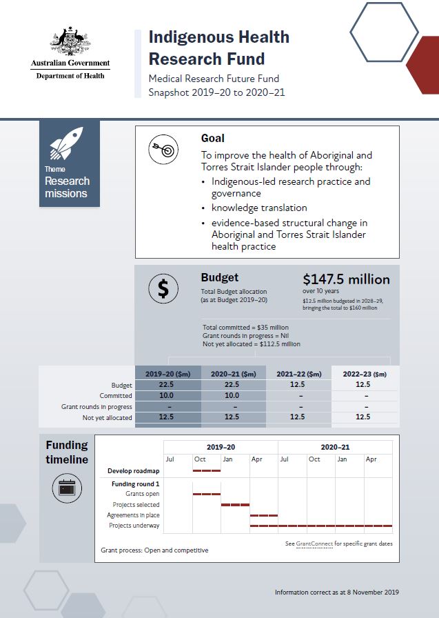
MRFF snapshot – Indigenous Health Research Fund
This snapshot shows this initiative at a glance. It includes budgets, early funding priorities and grant timelines, as at November 2019. Researchers and other stakeholders can use it to plan for upcoming opportunities and see how the initiative will be established, expanded and embedded over time. -
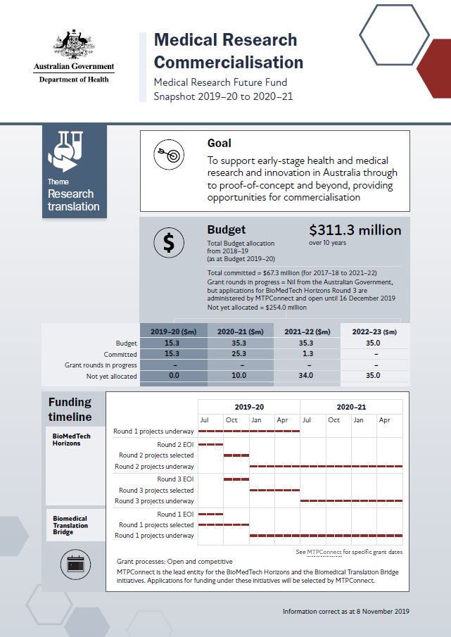
MRFF snapshot – Medical Research Commercialisation
This snapshot shows this initiative at a glance. It includes budgets, early funding priorities and grant timelines, as at November 2019. Researchers and other stakeholders can use it to plan for upcoming opportunities and see how the initiative will be established, expanded and embedded over time. -
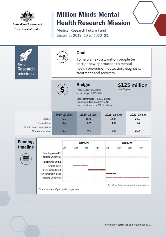
MRFF snapshot – Million Minds Mental Health Research Mission
This snapshot shows this Mission at a glance. It includes budgets, early funding priorities and grant timelines, as at November 2019. Researchers and other stakeholders can use it to plan for upcoming opportunities and see how the Mission will be established, expanded and embedded over time. -
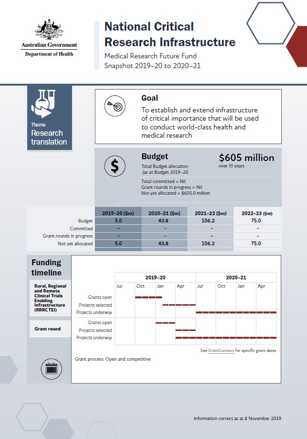
MRFF snapshot – National Critical Research Infrastructure
This snapshot shows this initiative at a glance. It includes budgets, early funding priorities and grant timelines, as at November 2019. Researchers and other stakeholders can use it to plan for upcoming opportunities and see how the initiative will be established, expanded and embedded over time. -
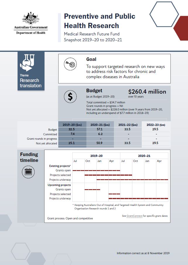
MRFF snapshot – Preventive and Public Health Research
This snapshot shows this initiative at a glance. It includes budgets, early funding priorities and grant timelines, as at November 2019. Researchers and other stakeholders can use it to plan for upcoming opportunities and see how the initiative will be established, expanded and embedded over time. -
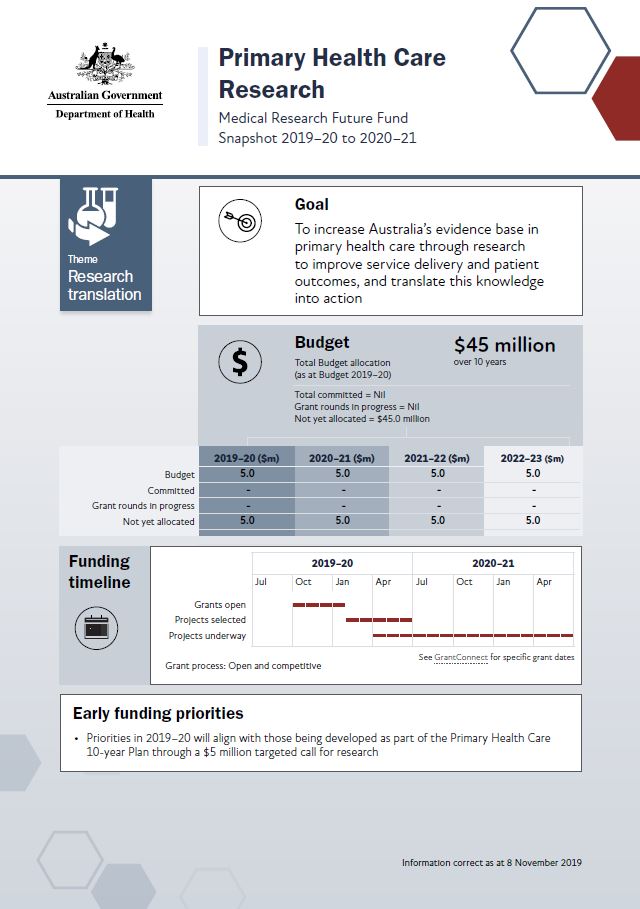
MRFF snapshot – Primary Health Care Research
This snapshot shows this initiative at a glance. It includes budgets, early funding priorities and grant timelines, as at November 2019. Researchers and other stakeholders can use it to plan for upcoming opportunities and see how the initiative will be established, expanded and embedded over time. -
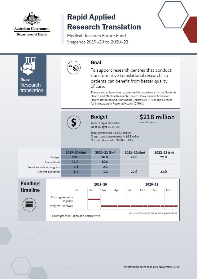
MRFF snapshot – Rapid Applied Research Translation
This snapshot shows this initiative at a glance. It includes budgets, early funding priorities and grant timelines, as of November 2019. Researchers and other stakeholders can use it to plan for upcoming opportunities and see how the initiative will be established, expanded and embedded over time. -
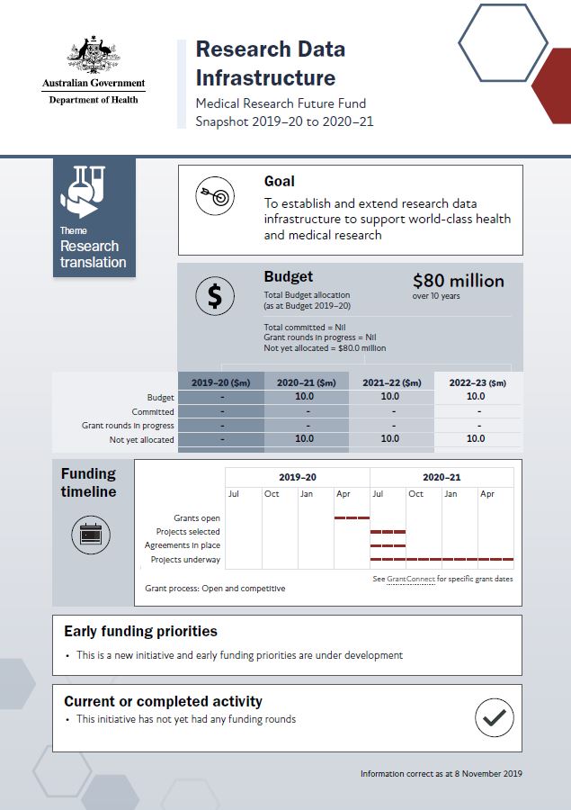
MRFF snapshot – Research Data Infrastructure
This snapshot shows this initiative at a glance. It includes budgets, early funding priorities and grant timelines, as at November 2019. Researchers and other stakeholders can use it to plan for upcoming opportunities and see how the initiative will be established, expanded and embedded over time. -
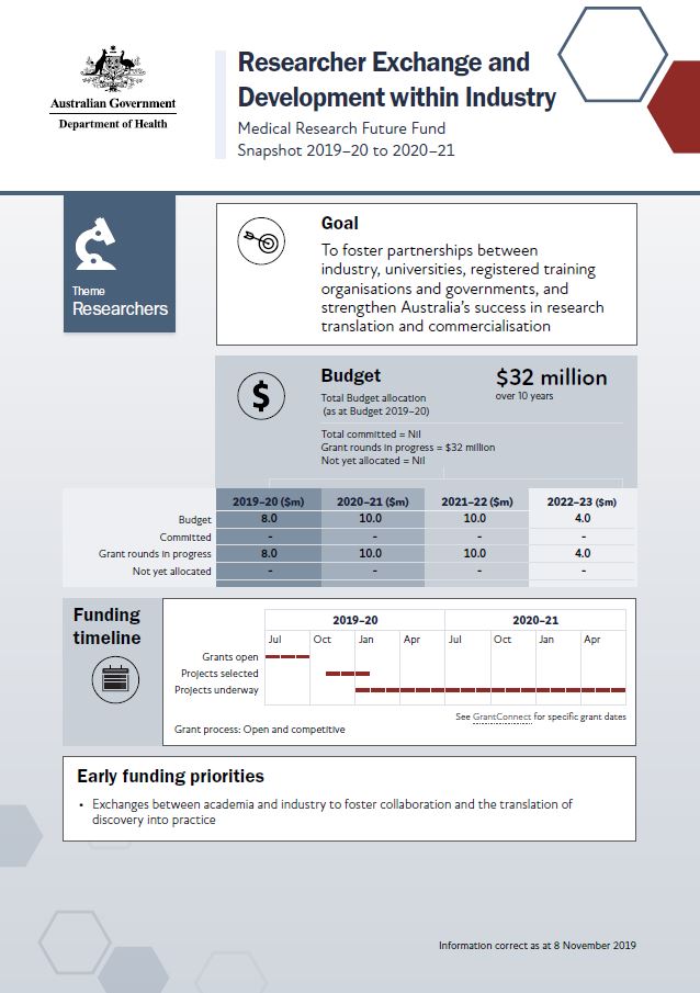
MRFF snapshot – Researcher Exchange and Development within Industry (REDI)
This snapshot shows this initiative at a glance. It includes budgets, early funding priorities and grant timelines, as at November 2019. Researchers and other stakeholders can use it to plan for upcoming opportunities and see how the initiative will be established, expanded and embedded over time. -
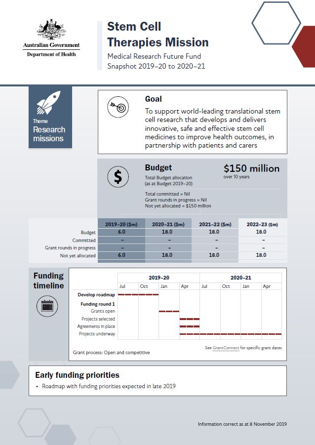
MRFF snapshot – Stem Cell Therapies Mission
This snapshot shows this Mission at a glance. It includes budgets, early funding priorities and grant timelines, as at November 2019. Researchers and other stakeholders can use it to plan for upcoming opportunities and see how the Mission will be established, expanded and embedded over time. -
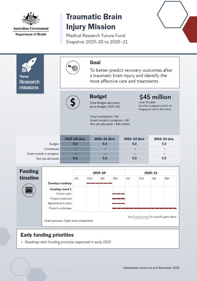
MRFF snapshot – Traumatic Brain Injury Mission
This snapshot shows this mission at a glance. It includes budgets, early funding priorities and grant timelines, as at November 2019. Researchers and other stakeholders can use it to plan for upcoming opportunities and see how the mission will be established, expanded and embedded over time. -
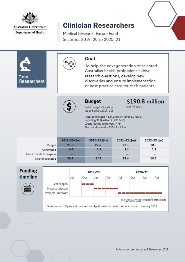
MRFF snapshot – Clinician Researchers
This snapshot shows this initiative at a glance. It includes budgets, early funding priorities and grant timelines, as at November 2019. Researchers and other stakeholders can use it to plan for upcoming opportunities and see how the initiative will be established, expanded and embedded over time. -
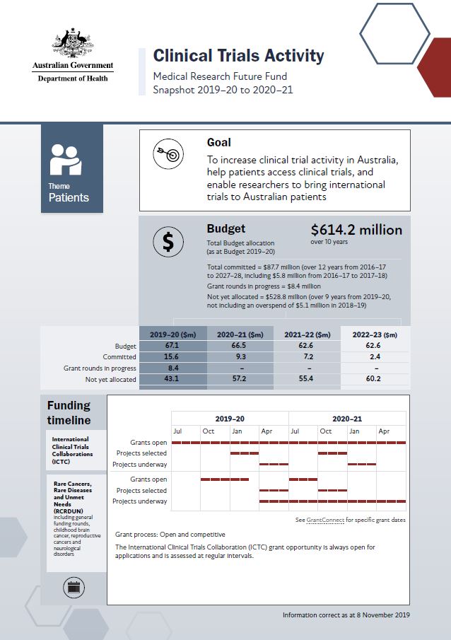
MRFF snapshot – Clinical Trials Activity
This snapshot shows this initiative at a glance. It includes budgets, early funding priorities and grant timelines, as at November 2019. Researchers and other stakeholders can use it to plan for upcoming opportunities and see how the initiative will be established, expanded and embedded over time. -
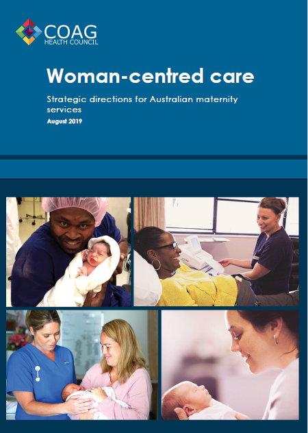
Woman-centred care: Strategic directions for Australian maternity services
This document outlines a national strategy to support the delivery of maternity services to women, from conception until 12 months after the pregnancy or birth. -
Report on the Outcome of Public Consultation on the Serious Incident Response Scheme
This report details outcomes from public consultation on the finer details of the operation of a Serious Incident Response Scheme (SIRS). -
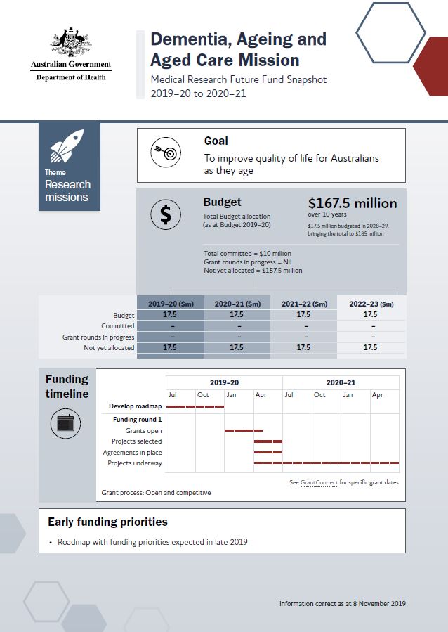
MRFF snapshot – Dementia, Ageing and Aged Care Mission
This snapshot shows this Mission at a glance. It includes budget, early funding priorities and grant timelines, as at November 2019. Researchers and other stakeholders can use it to plan for upcoming opportunities and see how the Mission will be established, expanded and embedded over time. -
Prevalence Study for a Serious Incident Response Scheme (SIRS)
The Prevalence Study for a Serious Incident Response Scheme (SIRS) report looks at incidents of abuse between residents of aged care facilities that are currently exempt from reporting. It gives options for reporting these incidents under a SIRS. -
Towards Zero Suicide Prevention Forum: summary of outcomes
This document summarises the outcomes of various workshops held during the Towards Zero Suicide Prevention Forum. -
Report detailing key themes and early findings to support initial advice of the National Suicide Prevention Adviser
This report summarises contextual information on the impact of suicide in Australia and suicide prevention approaches, as well as a summary of work done by the National Suicide Prevention Adviser and Taskforce.