Filter results
You can narrow down the results using the filters
Audience
Publication type
Topics
Our work
Diseases
9287 results
-
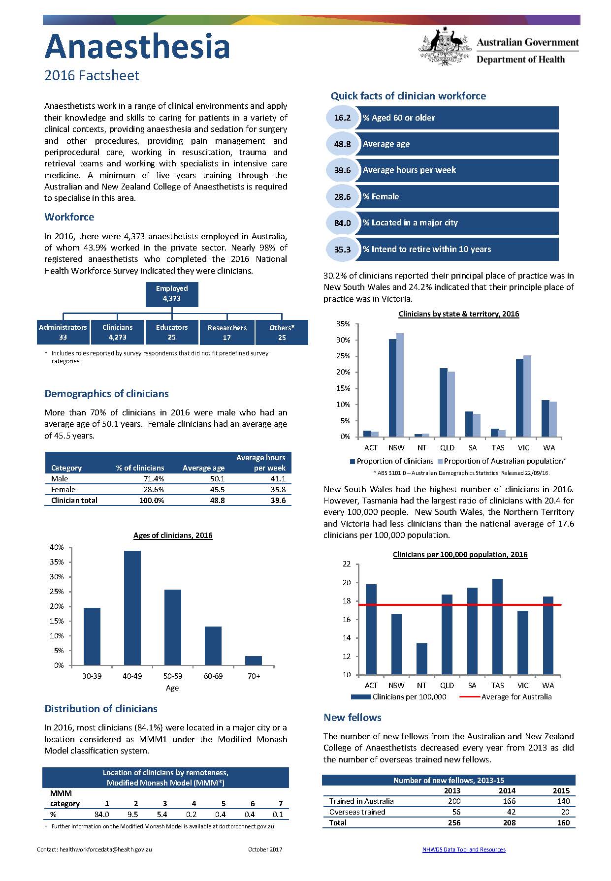
Anaesthesia workforce – MWRAC fact sheet
This Medical Workforce Reform Advisory Committee (MWRAC) fact sheet provides information on the demographics and distribution of the anaesthesia workforce. -
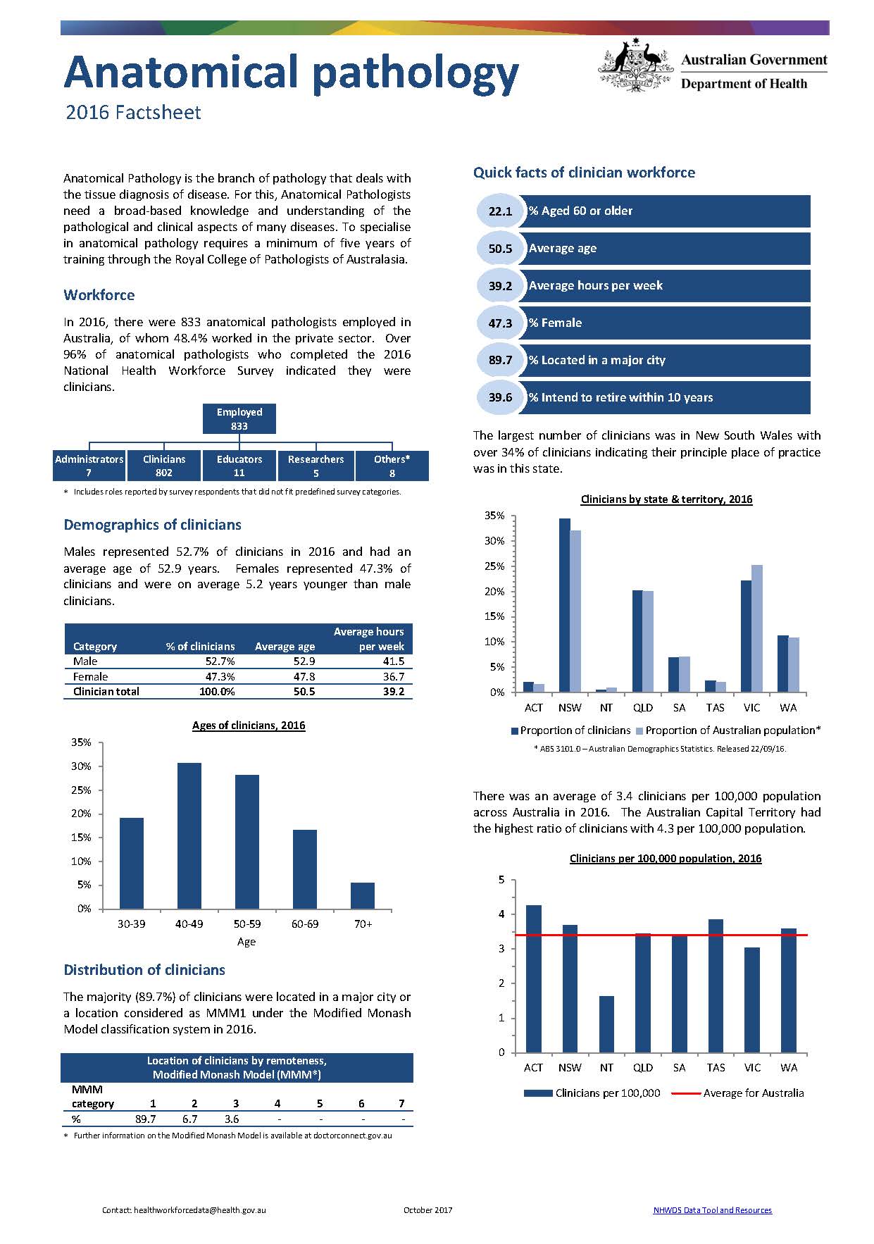
Anatomical pathology workforce – MWRAC fact sheet
This Medical Workforce Reform Advisory Committee (MWRAC) fact sheet provides information on the demographics and distribution of the anatomical pathology workforce. -
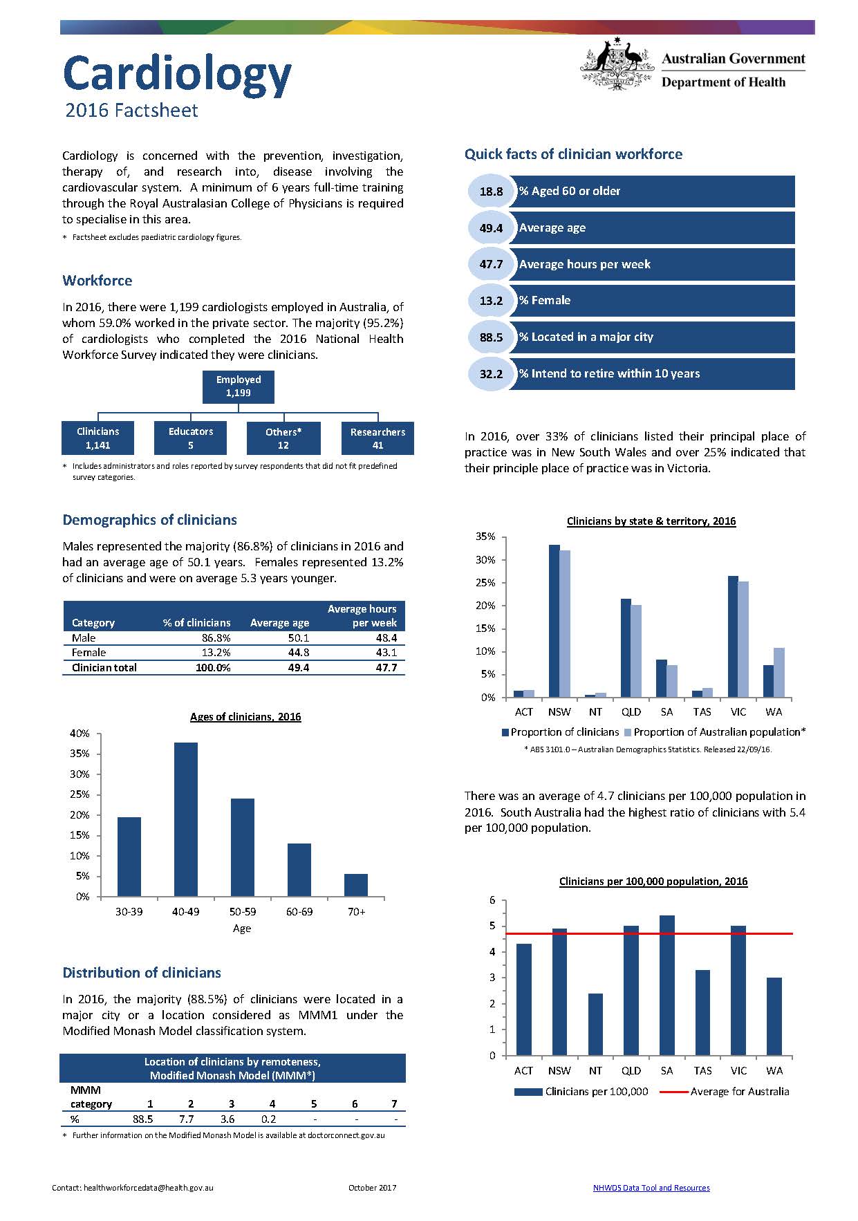
Cardiology workforce – MWRAC fact sheet
This Medical Workforce Reform Advisory Committee (MWRAC) fact sheet provides information on the demographics and distribution of the cardiology workforce. -
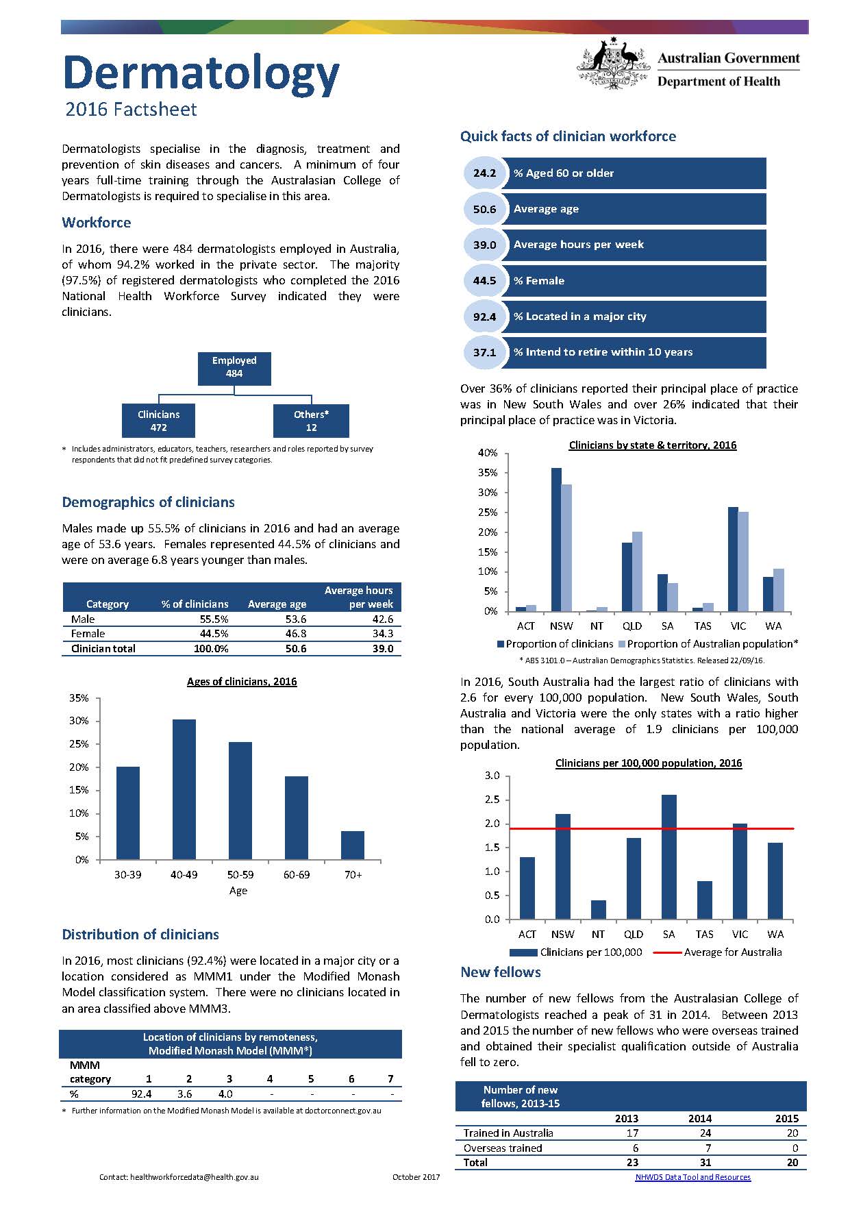
Dermatology workforce – MWRAC fact sheet
This Medical Workforce Reform Advisory Committee (MWRAC) fact sheet provides information on the demographics and distribution of the dermatology workforce. -
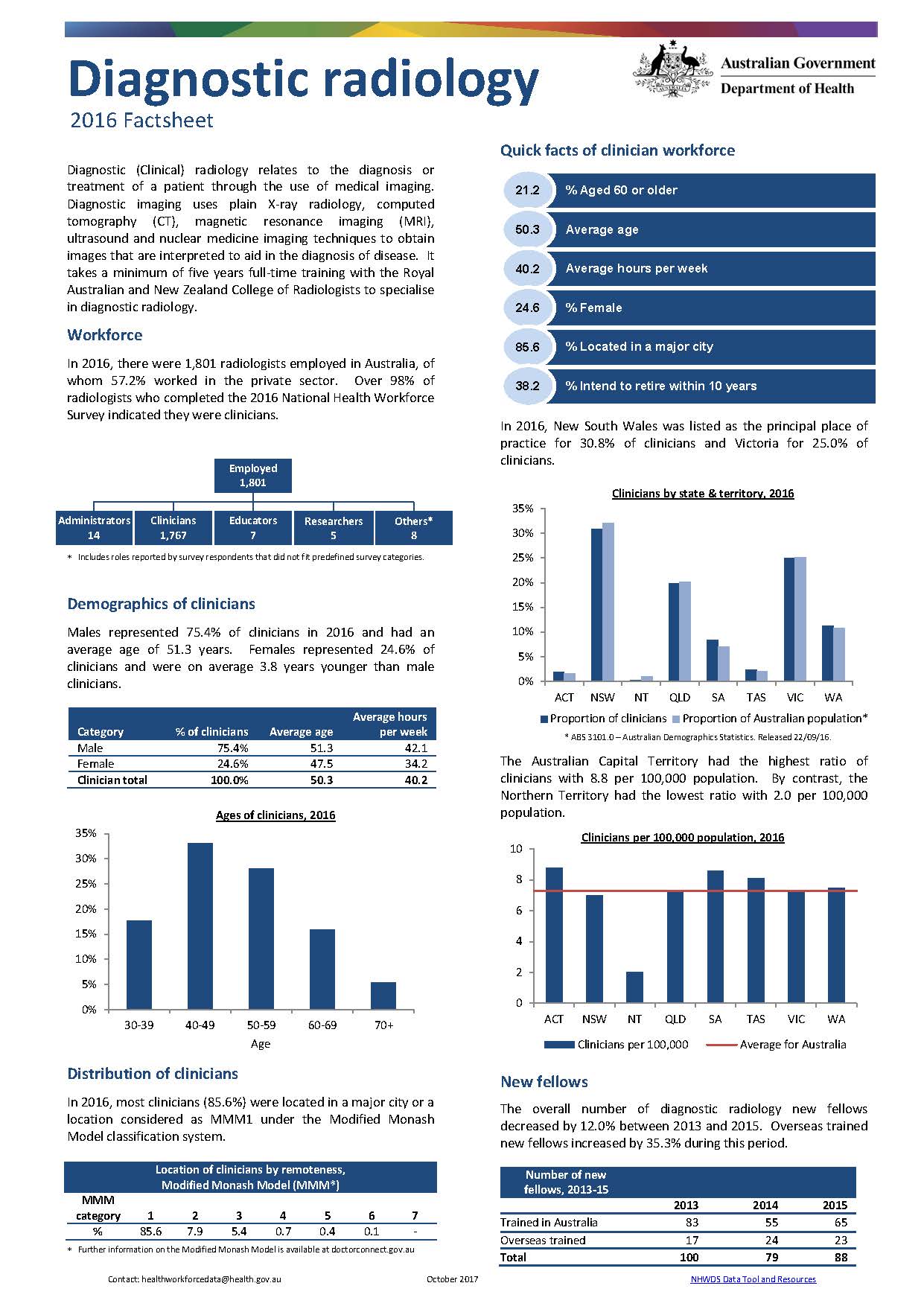
Diagnostic radiology workforce – MWRAC fact sheet
This Medical Workforce Reform Advisory Committee (MWRAC) fact sheet provides information on the demographics and distribution of the diagnostic radiology workforce. -
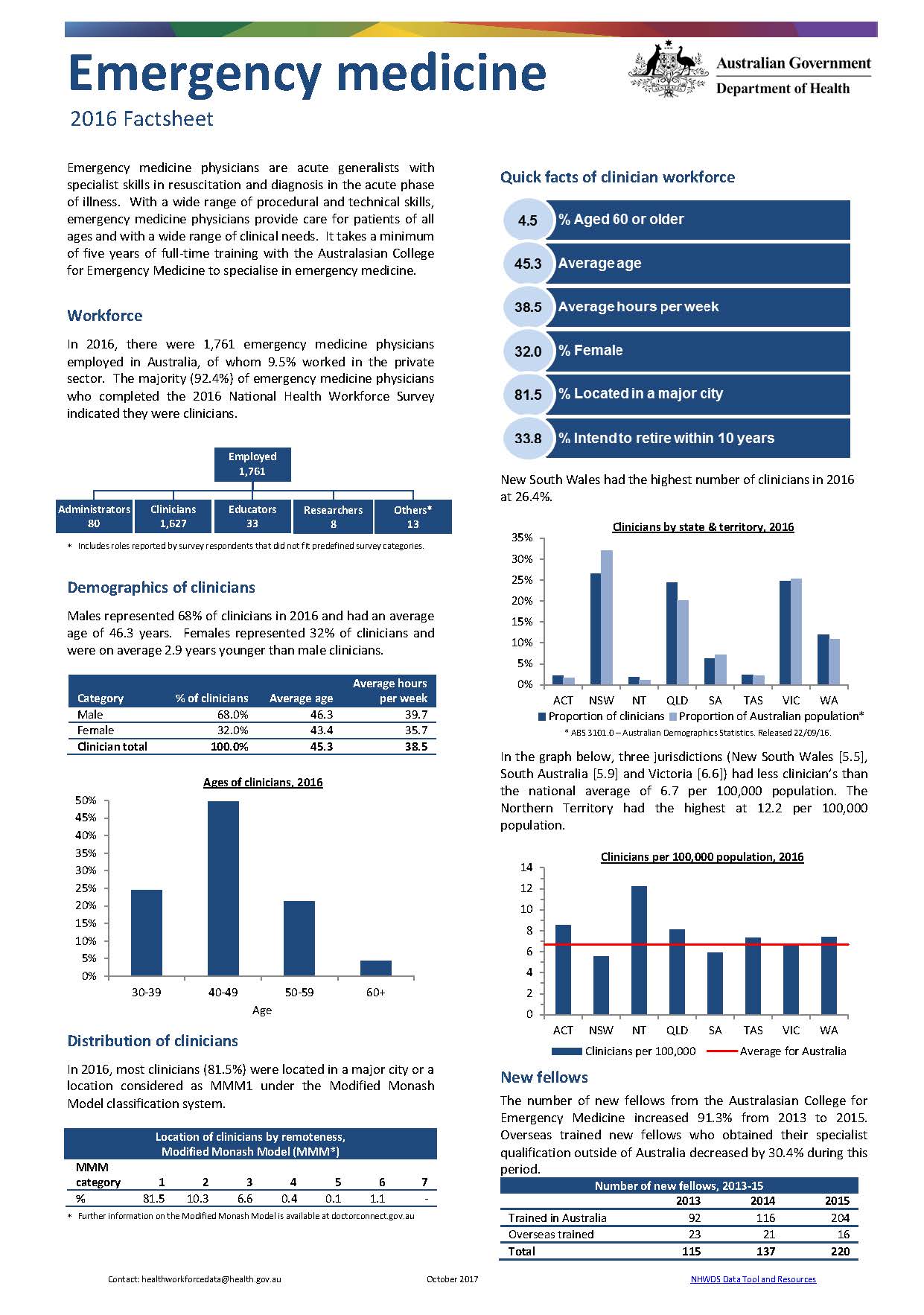
Emergency medicine workforce – MWRAC fact sheet
This Medical Workforce Reform Advisory Committee (MWRAC) fact sheet provides information on the demographics and distribution of the emergency medicine workforce. -
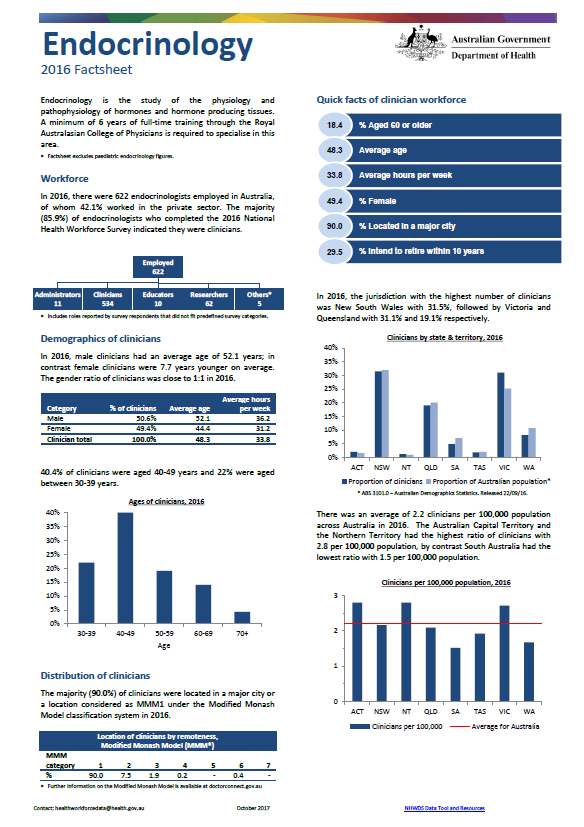
Endocrinology workforce – MWRAC fact sheet
This Medical Workforce Reform Advisory Committee (MWRAC) fact sheet provides information on the demographics and distribution of the endocrinology workforce. -
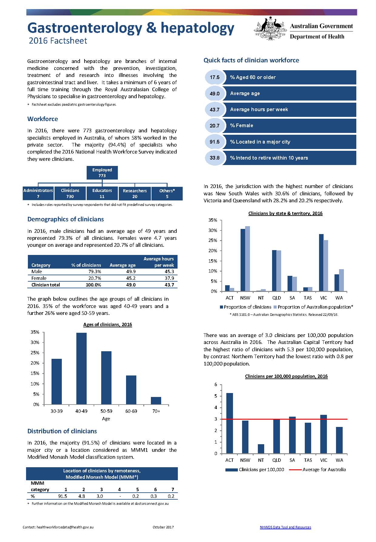
Gastroenterology and hepatology workforce – MWRAC fact sheet
This Medical Workforce Reform Advisory Committee (MWRAC) fact sheet provides information on the demographics and distribution of the gastroenterology and hepatology workforce. -
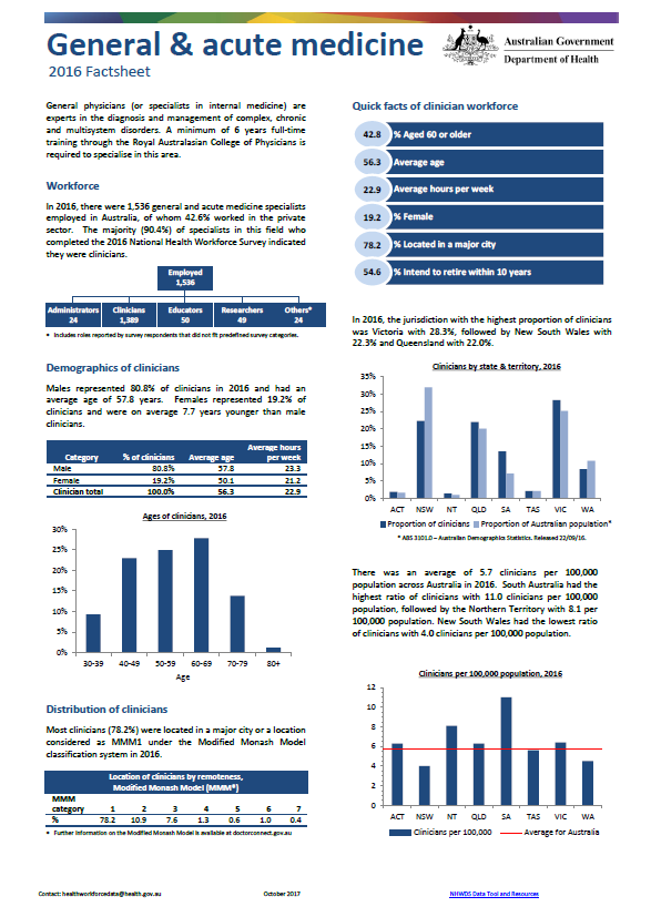
General and acute medicine workforce – MWRAC fact sheet
This Medical Workforce Reform Advisory Committee (MWRAC) fact sheet provides information on the demographics and distribution of the general and acute medicine workforce. -
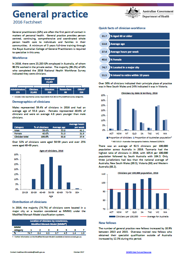
General practice workforce – MWRAC fact sheet
This Medical Workforce Reform Advisory Committee (MWRAC) fact sheet provides information on the demographics and distribution of the general practice workforce. -
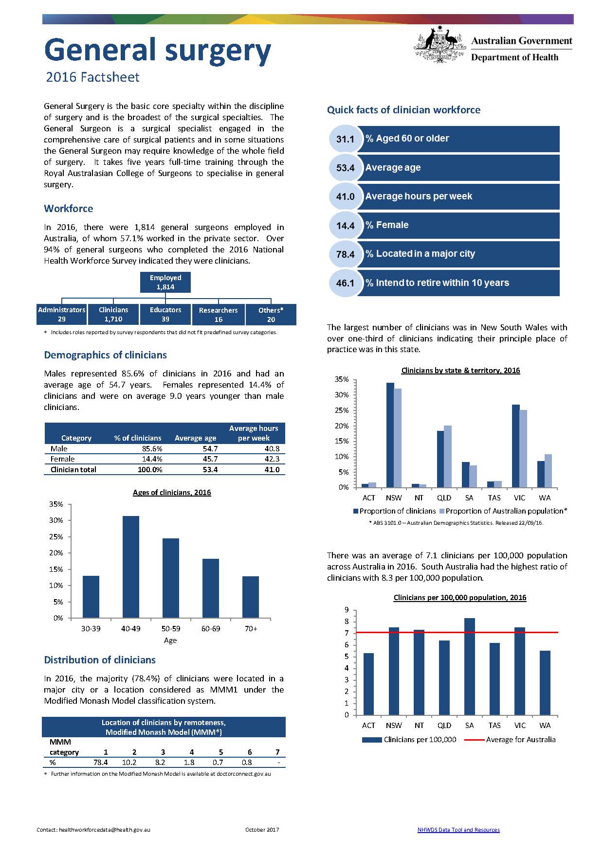
General surgery workforce – MWRAC fact sheet
This Medical Workforce Reform Advisory Committee (MWRAC) fact sheet provides information on the demographics and distribution of the general surgery workforce. -
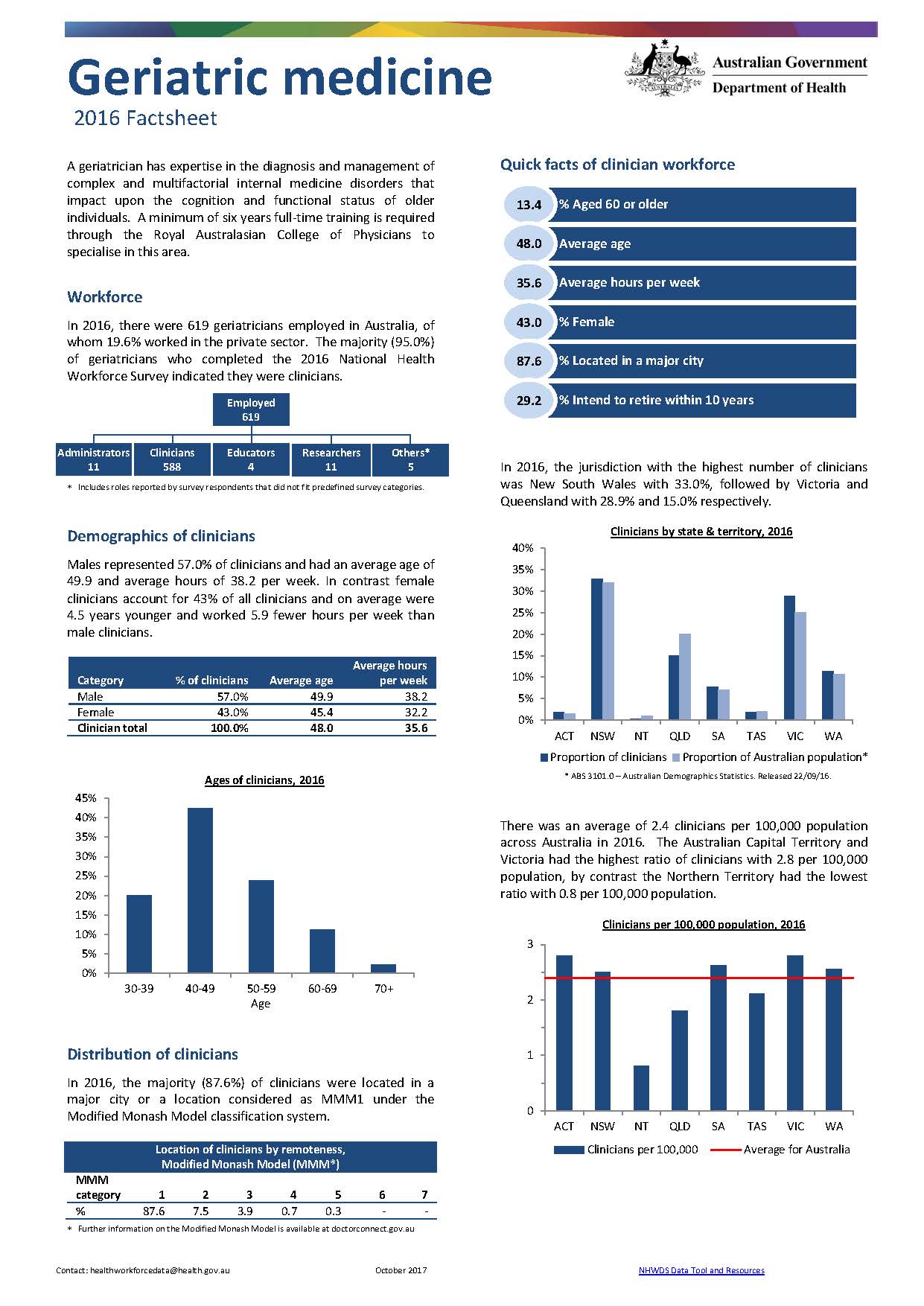
Geriatric medicine workforce – MWRAC fact sheet
This Medical Workforce Reform Advisory Committee (MWRAC) fact sheet provides information on the demographics and distribution of the geriatric medicine workforce. -
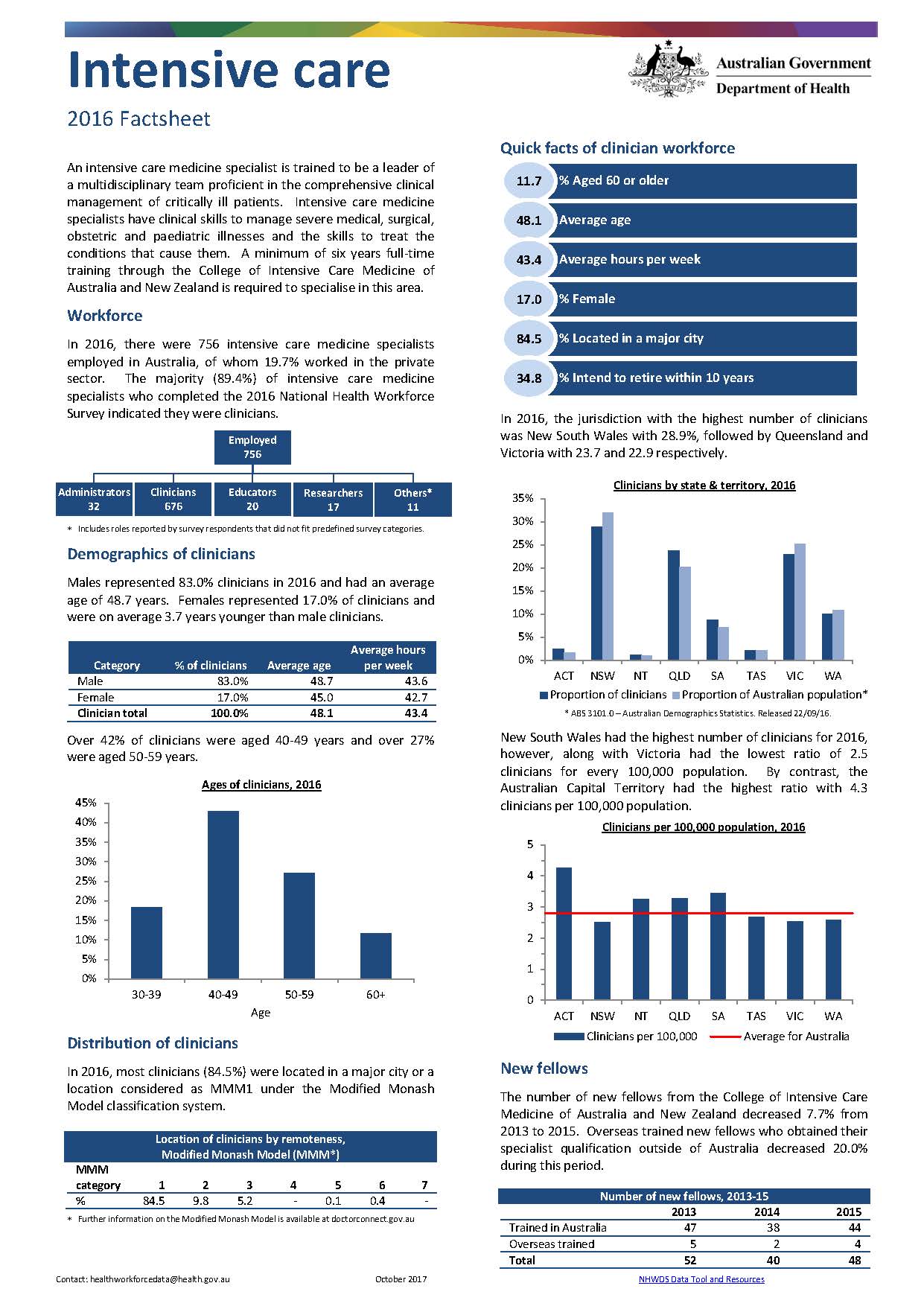
Intensive care medicine workforce – MWRAC fact sheet
This Medical Workforce Reform Advisory Committee (MWRAC) fact sheet provides information on the demographics and distribution of the intensive care medicine workforce. -
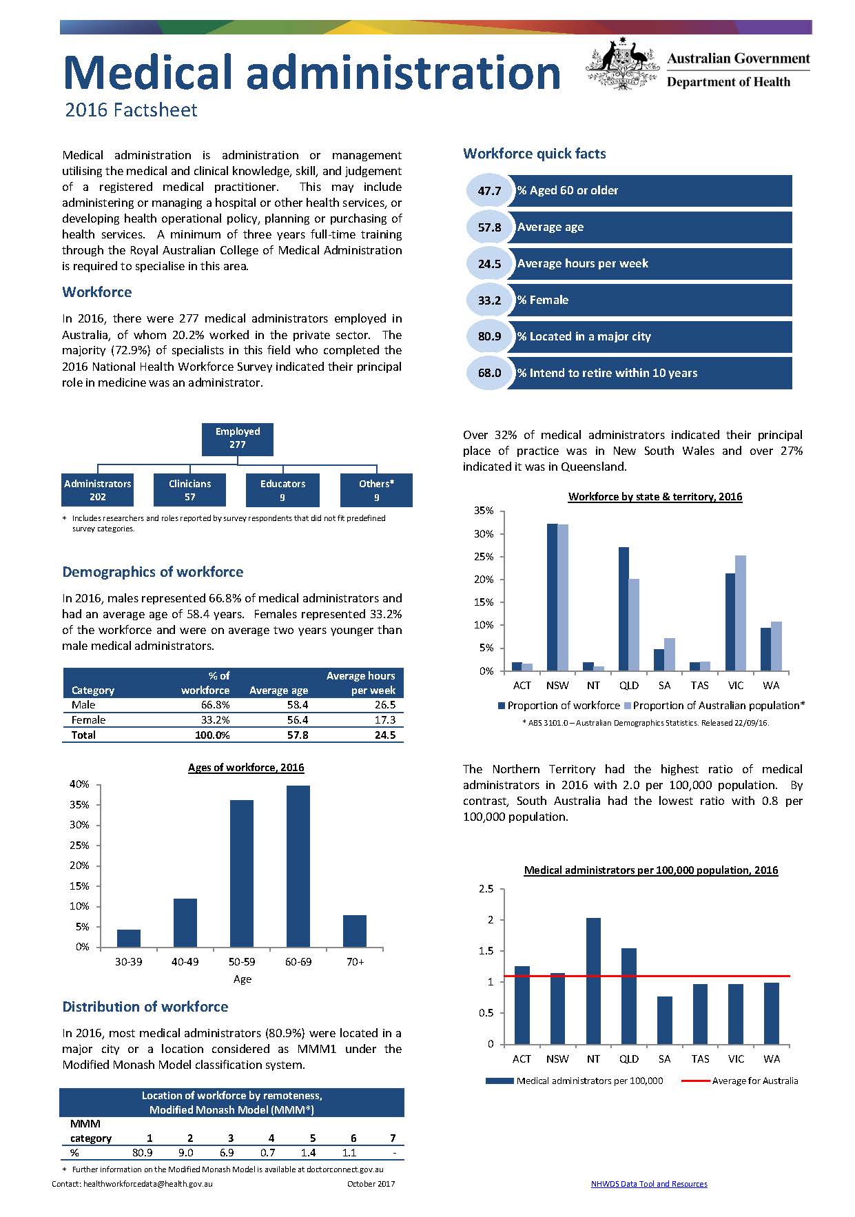
Medical administration workforce – MWRAC fact sheet
This Medical Workforce Reform Advisory Committee (MWRAC) fact sheet provides information on the demographics and distribution of the medical administration workforce. -
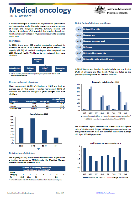
Medical oncology workforce – MWRAC fact sheet
This Medical Workforce Reform Advisory Committee (MWRAC) fact sheet provides information on the demographics and distribution of the medical oncology workforce. -
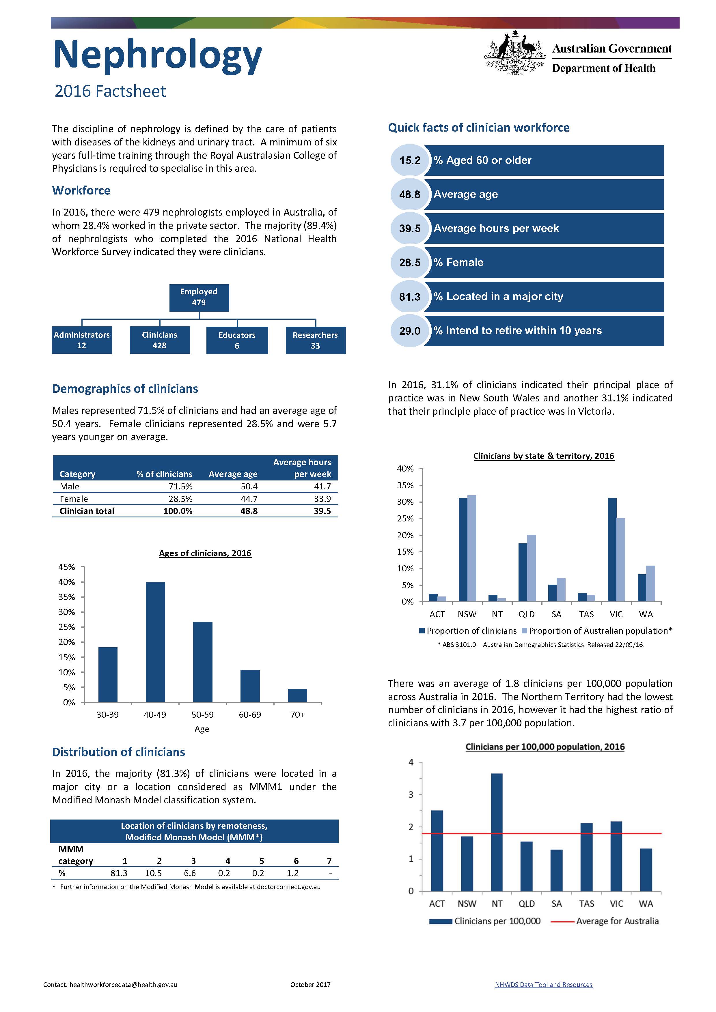
Nephrology workforce – MWRAC fact sheet
This Medical Workforce Reform Advisory Committee (MWRAC) fact sheet provides information on the demographics and distribution of the nephrology workforce. -
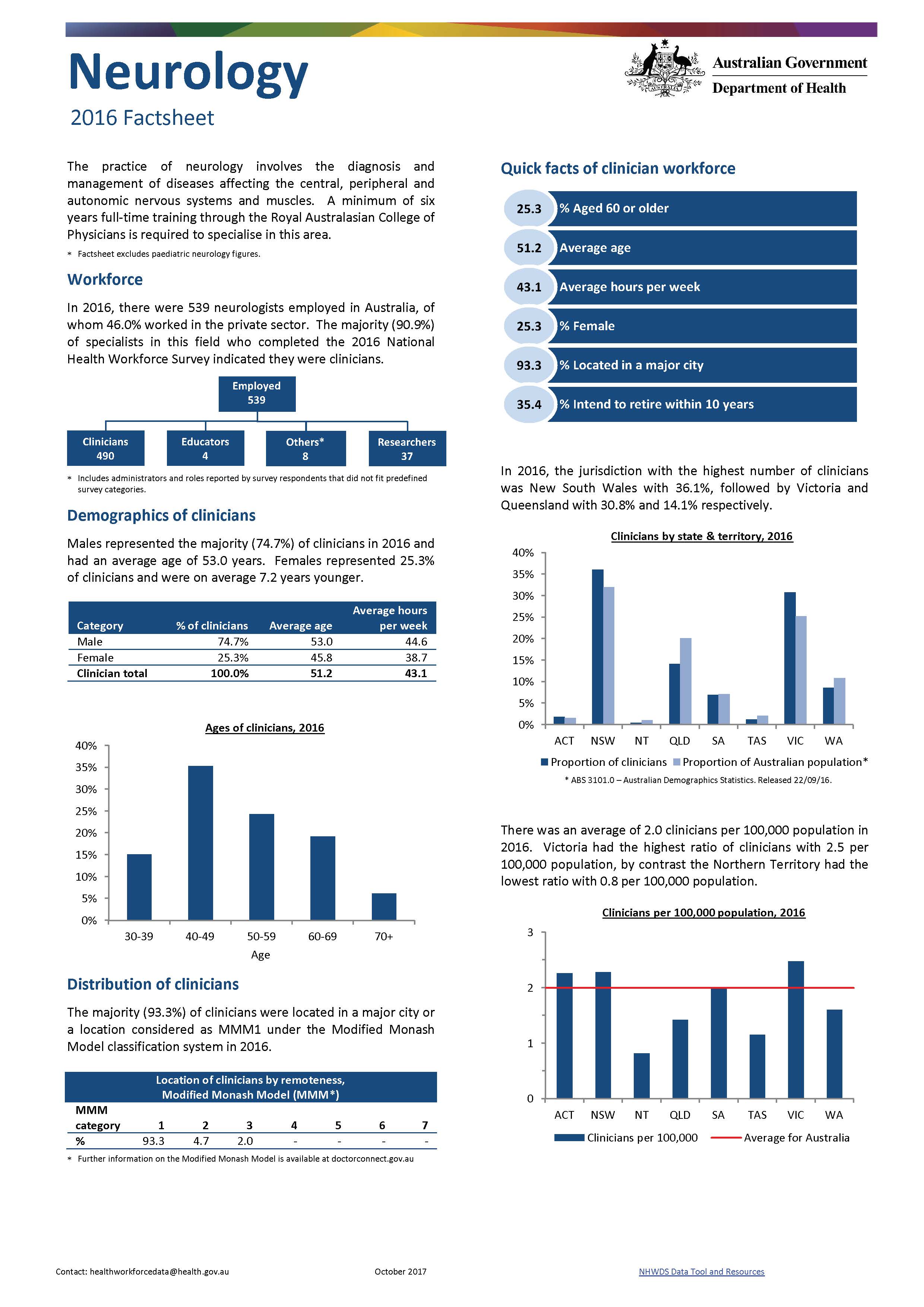
Neurology workforce – MWRAC fact sheet
This Medical Workforce Reform Advisory Committee (MWRAC) fact sheet provides information on the demographics and distribution of the neurology workforce. -
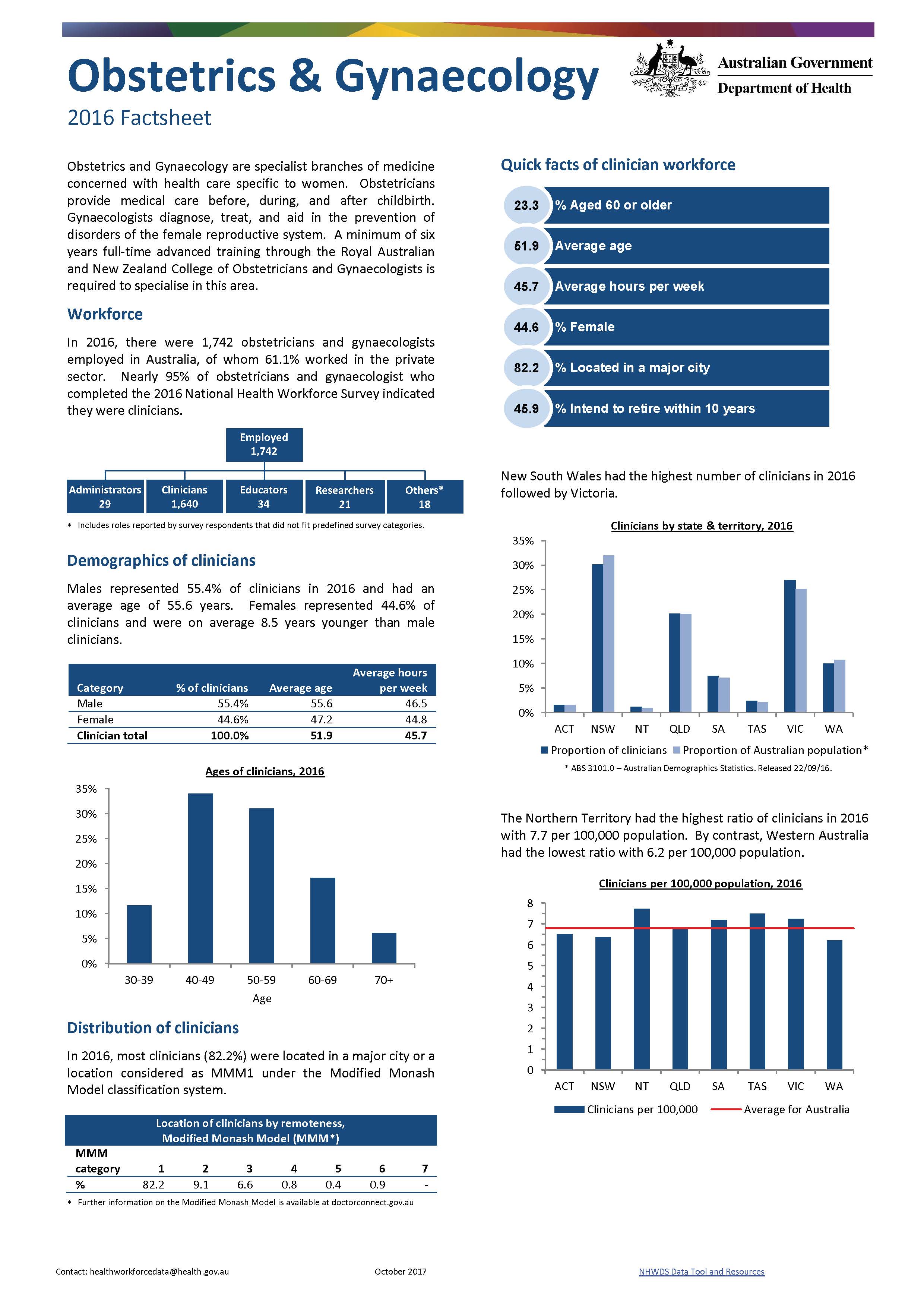
Obstetrics and gynaecology workforce – MWRAC fact sheet
This Medical Workforce Reform Advisory Committee (MWRAC) fact sheet provides information on the demographics and distribution of the obstetrics and gynaecology workforce. -
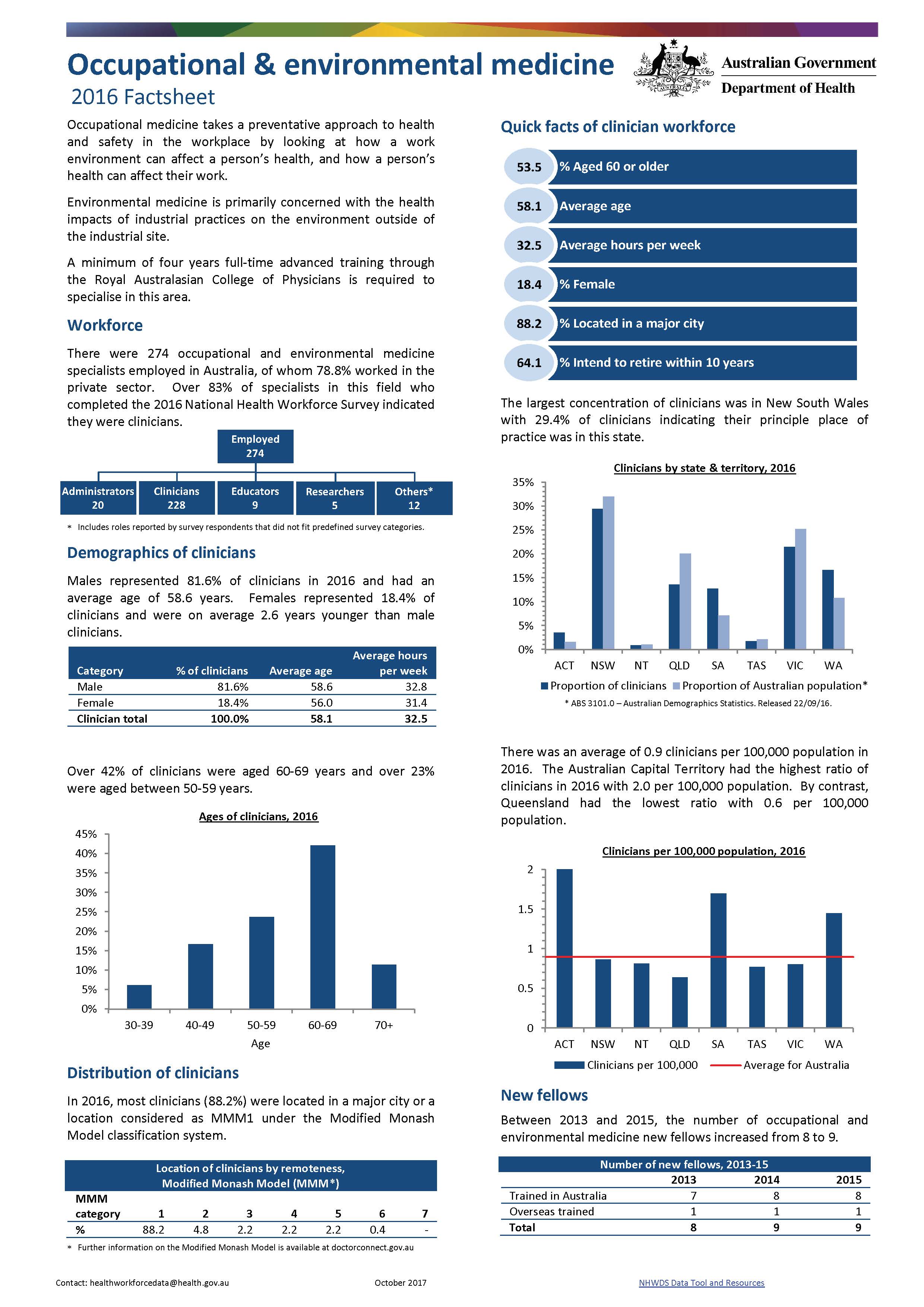
Occupational and environmental medicine workforce – MWRAC fact sheet
This Medical Workforce Reform Advisory Committee (MWRAC) fact sheet provides information on the demographics and distribution of the occupational and environmental medicine workforce. -
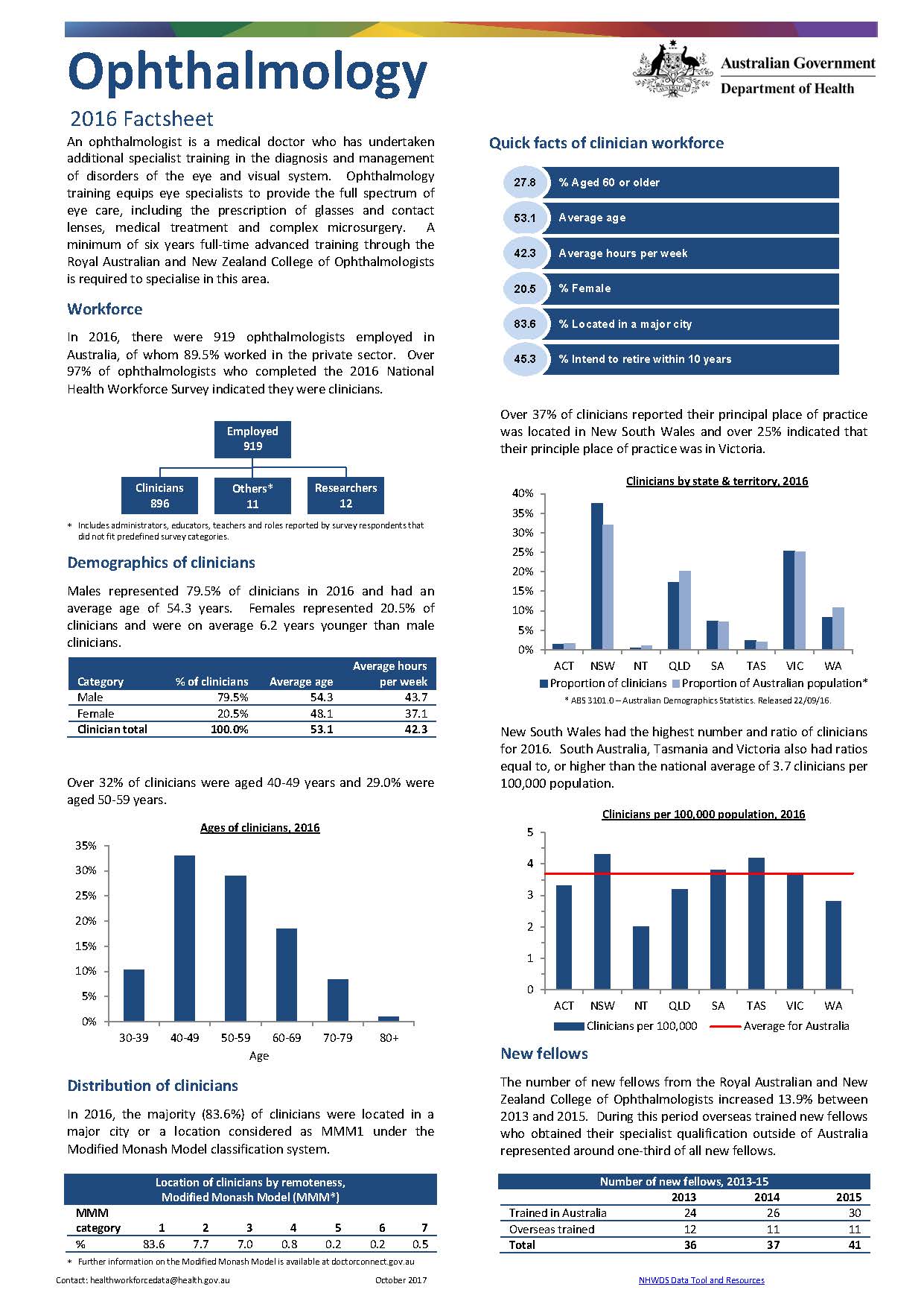
Ophthalmology workforce – MWRAC fact sheet
This Medical Workforce Reform Advisory Committee (MWRAC) fact sheet provides information on the demographics and distribution of the ophthalmology workforce. -
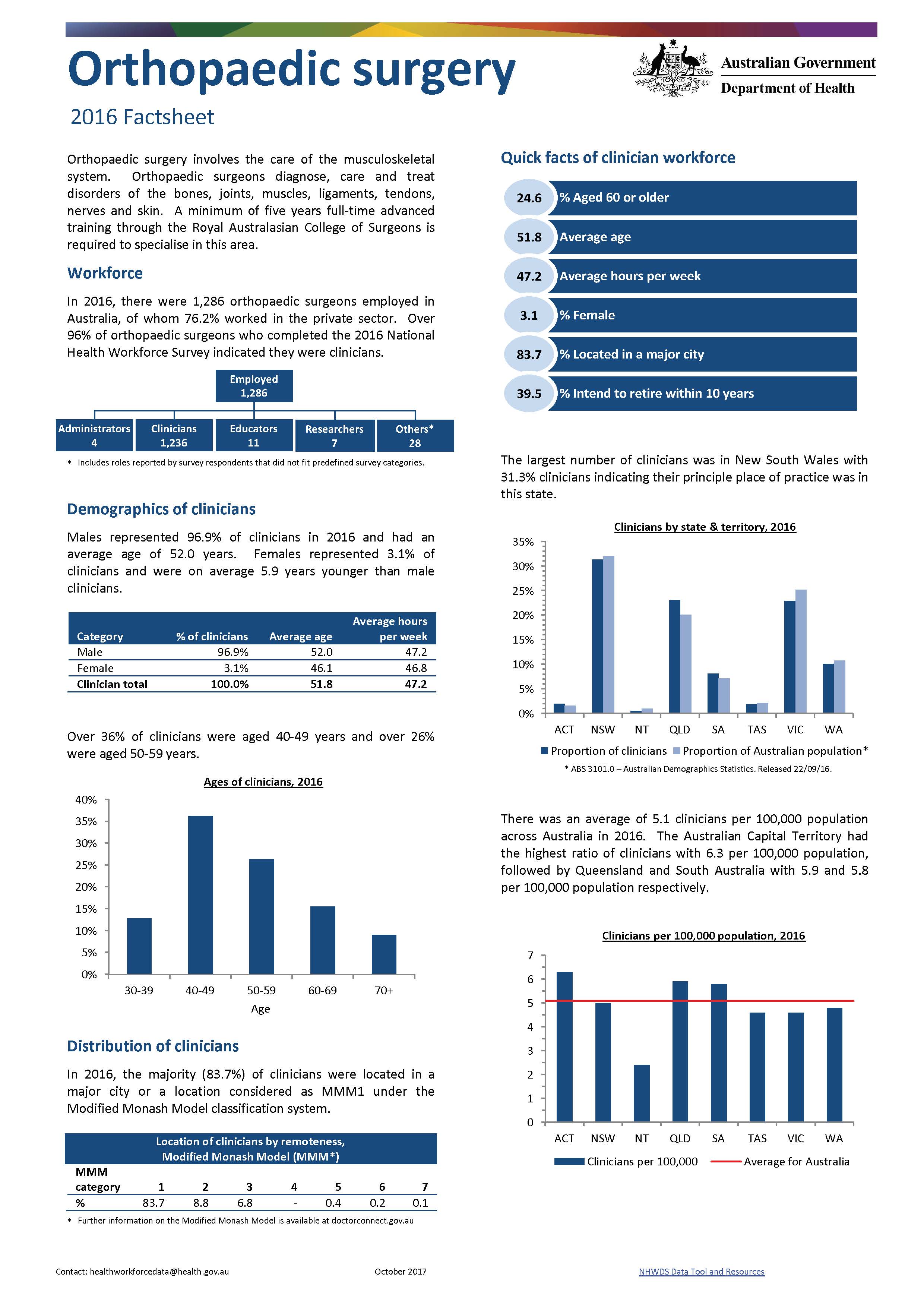
Orthopaedic surgery workforce – MWRAC fact sheet
This Medical Workforce Reform Advisory Committee (MWRAC) fact sheet provides information on the demographics and distribution of the orthopaedic surgery workforce. -
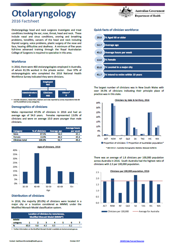
Otolaryngology workforce – MWRAC fact sheet
This Medical Workforce Reform Advisory Committee (MWRAC) fact sheet provides information on the demographics and distribution of the otolaryngology workforce. -
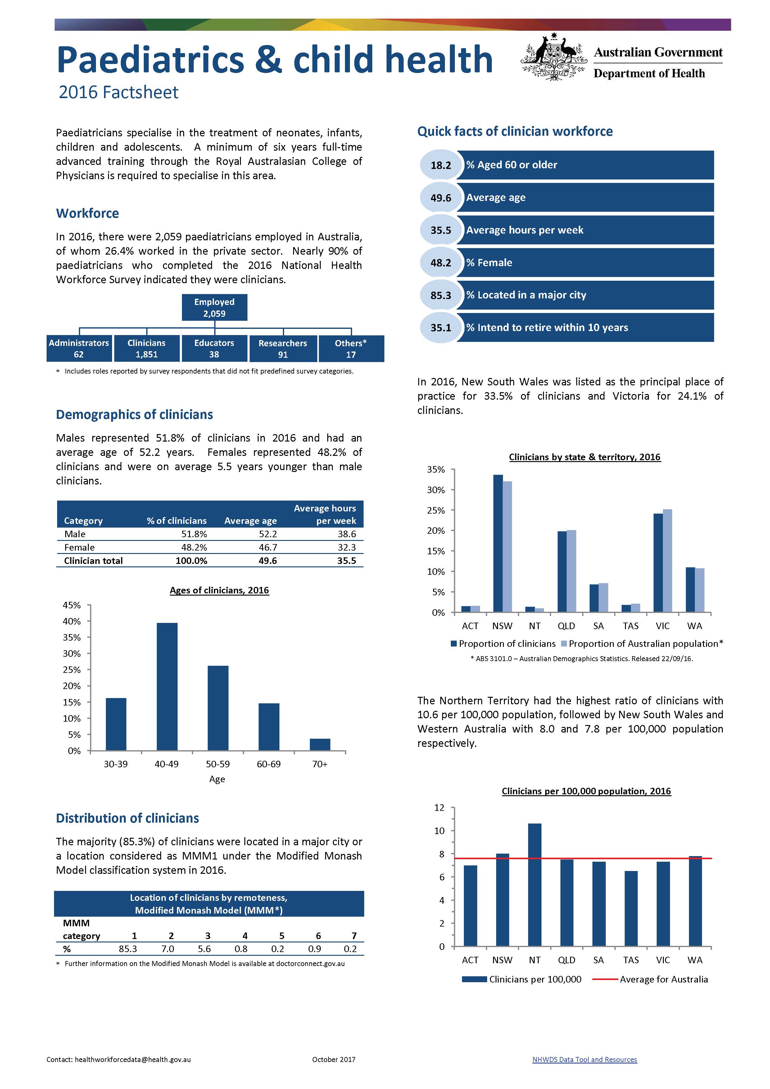
Paediatrics and child health workforce – MWRAC fact sheet
This Medical Workforce Reform Advisory Committee (MWRAC) fact sheet provides information on the demographics and distribution of the paediatrics and child health workforce. -
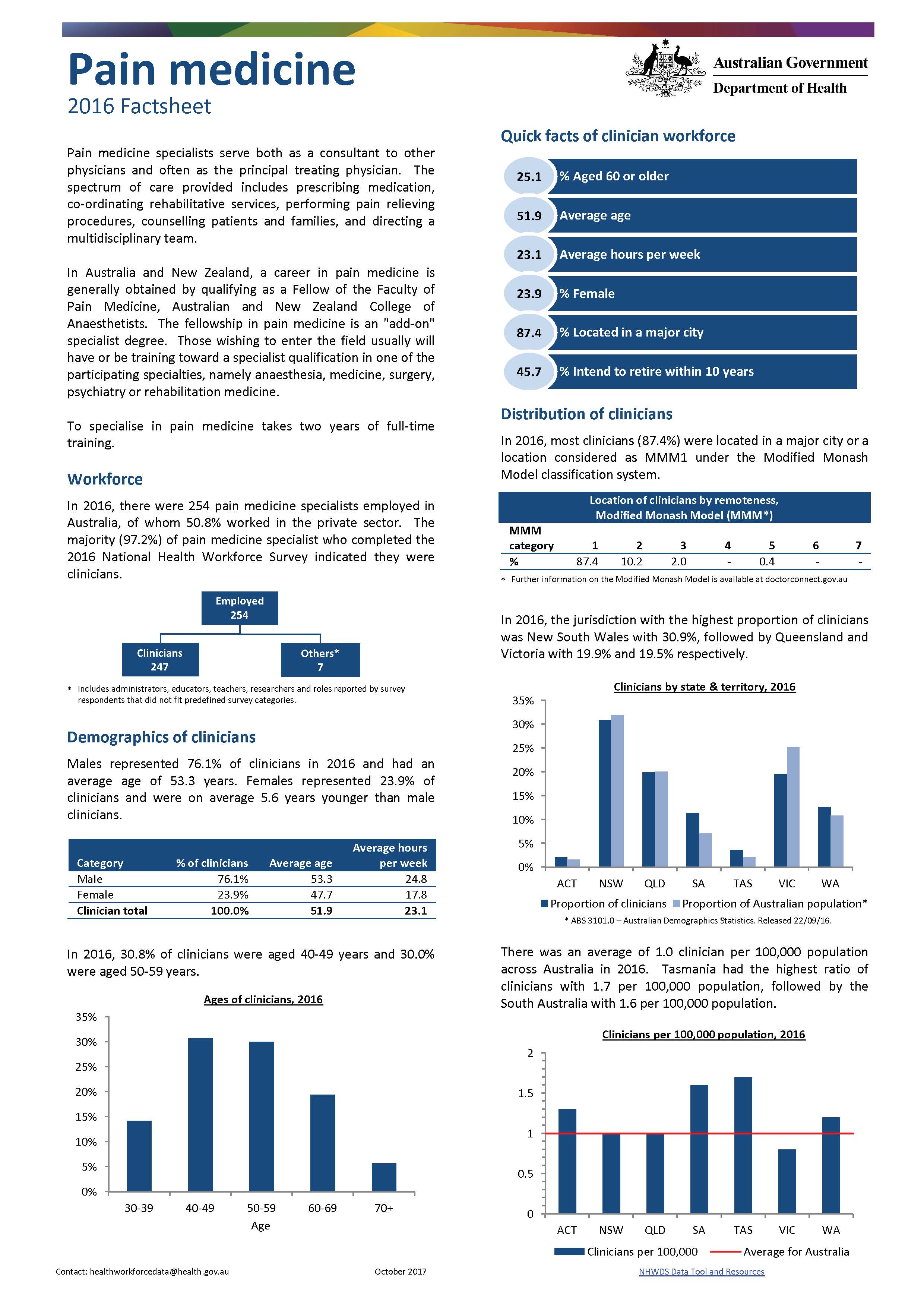
Pain medicine workforce – MWRAC fact sheet
This Medical Workforce Reform Advisory Committee (MWRAC) fact sheet provides information on the demographics and distribution of the pain medicine workforce. -
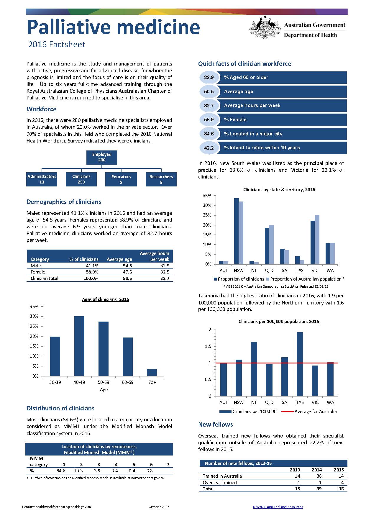
Palliative medicine workforce – MWRAC fact sheet
This Medical Workforce Reform Advisory Committee (MWRAC) fact sheet provides information on the demographics and distribution of the palliative medicine workforce.