Filter results
You can narrow down the results using the filters
Audience
Publication type
Topics
Our work
Diseases
9319 results
-
Report detailing key themes and early findings to support initial advice of the National Suicide Prevention Adviser
This report summarises contextual information on the impact of suicide in Australia and suicide prevention approaches, as well as a summary of work done by the National Suicide Prevention Adviser and Taskforce. -

Guidance for public officials on interacting with the tobacco industry
This document is for public officials who interact with the tobacco industry. It contains the legal framework placed on public agencies and officials under Article 5.3 of the World Health Organization (WHO) Framework Convention on Tobacco Control.
-
2018–19 Operations Report of the Aged Care Financing Authority (ACFA)
This is the seventh annual operations report for ACFA. It covers the period 1 July 2018 to 30 June 2019. -
Final clinical committee report for Principles and Rules
This report contains the recommendations the Principles and Rules Clinical Committee made to the MBS Review Taskforce, after public consultation. -
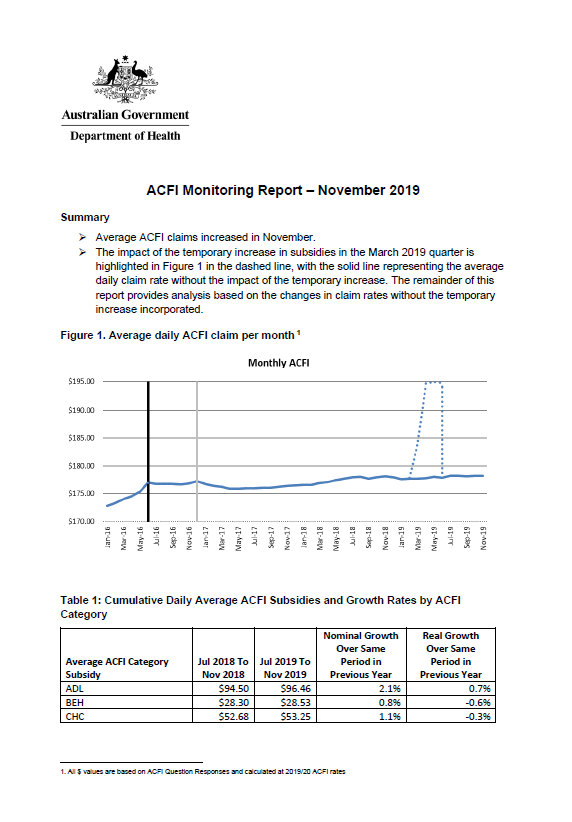
Aged care funding instrument (ACFI) monitoring report – November 2019
This report shows the monthly growth in ACFI subsidies compared to estimates for November 2019. -
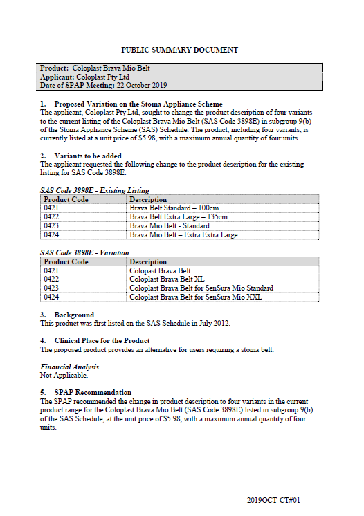
SPAP public summary documents – October 2019 – Coloplast Brava Mio Belt
This public summary document outlines a Stoma Product Assessment Panel (SPAP) recommendation to change the product description for 4 variants of the Coloplast Brava Mio Belt listed in subgroup 9(b) of the Stoma Appliance Scheme Schedule. -
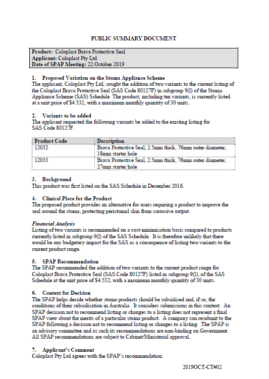
SPAP public summary documents – October 2019 – Coloplast Brava Protective Seal
This public summary document outlines a Stoma Product Assessment Panel (SPAP) recommendation to add 2 variants to the current listing of the Coloplast Brava Protective Seal to subgroup 9(l) of the Stoma Appliance Scheme Schedule. -
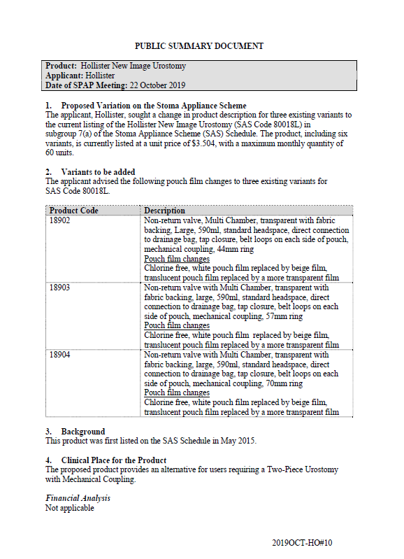
SPAP public summary documents – October 2019 – Hollister New Image Urostomy Pouch
This public summary document outlines a Stoma Product Assessment Panel (SPAP) recommendation to change the product description for 3 existing variants of the current listing of Hollister New Image Urostomy Pouch in subgroup7(a) of the Stoma Appliance Scheme Schedule. -
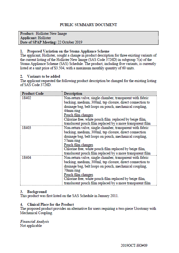
SPAP public summary documents – October 2019 – Hollister New Image Urostomy
This public summary document outlines a Stoma Product Assessment Panel (SPAP) recommendation to change the product description for 3 existing variants of the current listing of Hollister New Image Urostomy in subgroup 7(a) of the Stoma Appliance Scheme Schedule. -
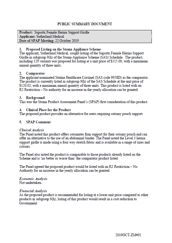
SPAP public summary documents – October 2019 – Sutherland Medical Suportx Female Hernia Support Girdle
This public summary document outlines a Stoma Product Assessment Panel (SPAP) recommendation to list the Sutherland Medical Suportx Female Hernia Support Girdle in subgroup 9(h) of the Stoma Appliance Scheme Schedule. -
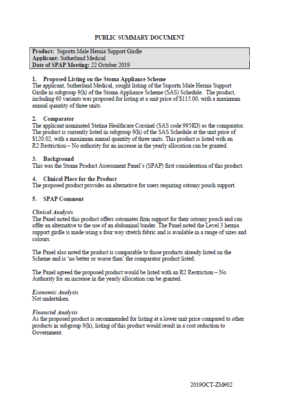
SPAP public summary documents – October 2019 – Sutherland Medical Suportx Male Hernia Support Girdle
This public summary document outlines a Stoma Product Assessment Panel (SPAP) recommendation to list the Sutherland Medical Suportx Male Hernia Support Girdle in subgroup 9(h) of the Stoma Appliance Scheme Schedule. -
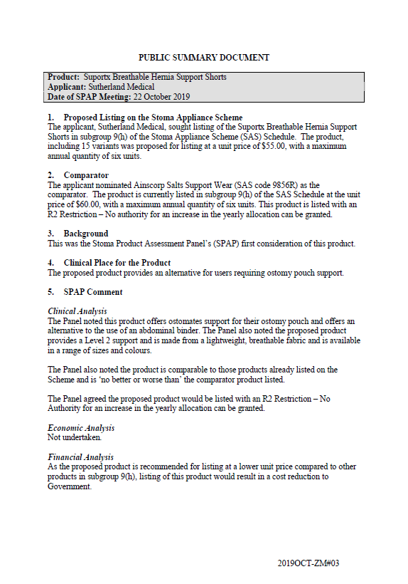
SPAP public summary documents – October 2019 – Sutherland Medical Suportx Breathable Hernia Support Shorts
This public summary document outlines a Stoma Product Assessment Panel (SPAP) recommendation to list the Sutherland Medical Suportx Breathable Hernia Support Shorts in subgroup 9(h) of the Stoma Appliance Scheme Schedule. -
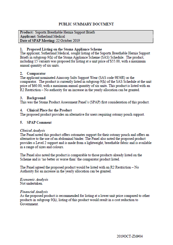
SPAP public summary documents – October 2019 – Sutherland Medical Suportx Breathable Hernia Support Briefs
This public summary document outlines a Stoma Product Assessment Panel (SPAP) recommendation to list the Sutherland Medical Suportx Breathable Hernia Support Brief in subgroup 9(h) of the Stoma Appliance Scheme Schedule. -
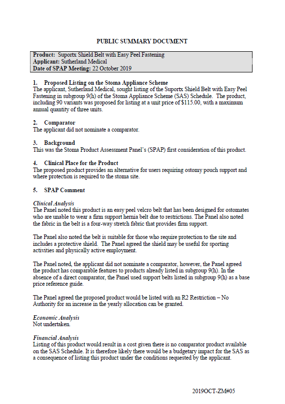
SPAP public summary documents – October 2019 – Sutherland Medical Suportx Shield Belt with Easy Peel Fastening
This public summary document outlines a Stoma Product Assessment Panel (SPAP) recommendation to list the Sutherland Medical Suportx Shield Belt with Easy Peel Fastening in subgroup 9(h) of the Stoma Appliance Scheme Schedule. -
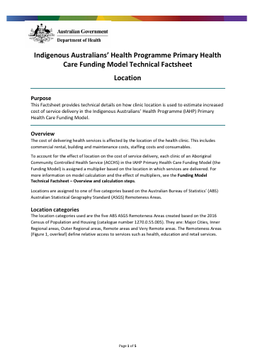
Indigenous Australians’ Health Programme primary health care funding model – location
This fact sheet describes how the model uses clinic location to estimate the increased cost of service delivery. -
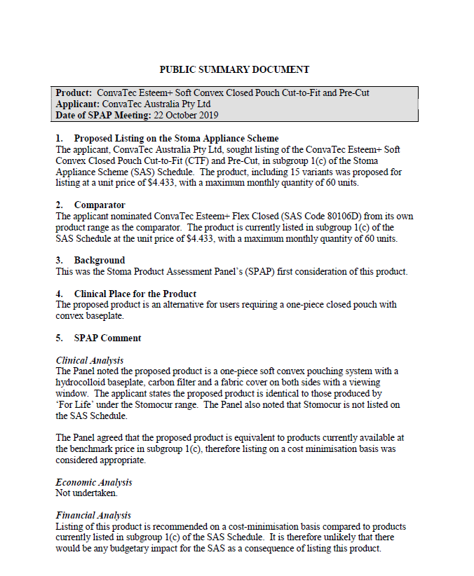
SPAP public summary documents – October 2019 – ConvaTec Esteem+ Soft Convex Closed Pouch Cut-to-Fit and Pre-Cut
This public summary document outlines a Stoma Product Assessment Panel (SPAP) recommendation to list the ConvaTec Esteem+ Soft Convex Closed Pouch Cut-to-Fit and Pre-Cut in subgroup 1(c) of the Stoma Appliance Scheme Schedule. -
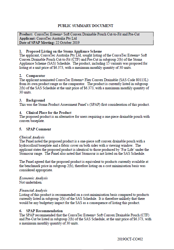
SPAP public summary documents – October 2019 – ConvaTec Esteem+ Soft Convex Drainable Pouch Cut-to-Fit and Pre-Cut
This public summary document outlines a Stoma Product Assessment Panel (SPAP) recommendation to list the ConvaTec Esteem+ Soft Convex Drainable Pouch Cut-to-Fit and Pre-Cut in subgroup 2(b) of the Stoma Appliance Scheme Schedule. -
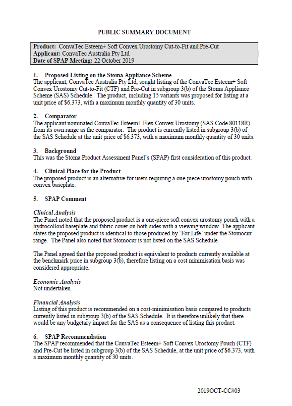
SPAP public summary documents – October 2019 – ConvaTec Esteem+ Soft Convex Urostomy Cut-to-Fit and Pre-Cut
This public summary document outlines a Stoma Product Assessment Panel (SPAP) recommendation to list the ConvaTec Esteem+ oft Convex Urostomy Cut-to-Fit and Pre-Cut in subgroup 3(b) of the Stoma Appliance Scheme Schedule. -
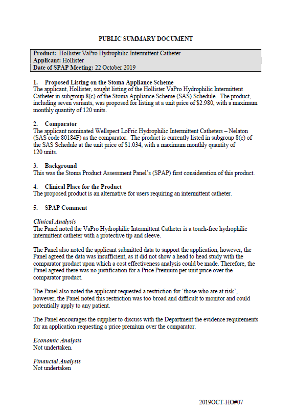
SPAP public summary documents – October 2019 – Hollister VaPro Hydrophilic Intermittent Catheter
This public summary document outlines a Stoma Product Assessment Panel (SPAP) recommendation not to list the Hollister VaPro Hydrophilic Intermittent Catheter on the Stoma Appliance Scheme Schedule. -
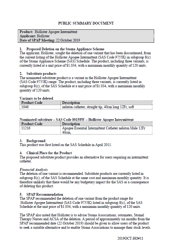
SPAP public summary documents – October 2019 – Hollister Apogee Intermittent Catheter
This public summary document outlines a Stoma Product Assessment Panel (SPAP) recommendation to delete 1 discontinued variant of the Hollister Apogee Intermittent Catheter from subgroup 8(c) of the Stoma Appliance Scheme Schedule. -
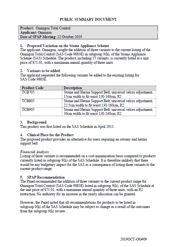
SPAP public summary documents – October 2019 – Omnigon Total Control
This public summary document outlines a Stoma Product Assessment Panel (SPAP) recommendation to add 3 variants to the current listing of Omnigon Total Control in subgroup 9(h) of the Stoma Appliance Scheme Schedule. -
SPAP public summary documents – October 2019 – Omnigon Support Briefs for Her addition
This public summary document outlines a Stoma Product Assessment Panel (SPAP) recommendation to add 1 variant to the current listing of Omnigon Support Briefs for Her in subgroup 9(h) of the Stoma Appliance Scheme Schedule. -
SPAP public summary documents – October 2019 – Omnigon Kool Knit
This public summary document outlines a Stoma Product Assessment Panel (SPAP) recommendation to add 5 variants to the current listing of Omnigon Kool Knit in subgroup 9(h) of the Stoma Appliance Scheme Schedule. -
SPAP public summary documents – October 2019 – Omnigon Stoma Support Belt
This public summary document outlines a Stoma Product Assessment Panel (SPAP) recommendation to add 2 variants to the current listing of Omnigon Stoma Support Belt in subgroup 9(h) of the Stoma Appliance Scheme Schedule. -
SPAP public summary documents – October 2019 – Omnigon Diamond Plus
This public summary document outlines a Stoma Product Assessment Panel (SPAP) recommendation to add 2 variants to the current listing of Omnigon Diamon Plus in subgroup 9(h) of the Stoma Appliance Scheme Schedule.